IMAGES TAKEN NEAR TO
Maldon Road, CHELMSFORD, CM3 4RJ
Introduction
This page details the photographs taken nearby to Maldon Road, CM3 4RJ by members of the Geograph project.
The Geograph project started in 2005 with the aim of publishing, organising and preserving representative images for every square kilometre of Great Britain, Ireland and the Isle of Man.

There are currently over 7.5m images from over14,400 individuals and you can help contribute to the project by visiting https://www.geograph.org.uk
Image Map
Images are licensed for reuse under creativecommons.org/licenses/by-sa/2.0
Notes
- Clicking on the map will re-center to the selected point.
- The higher the marker number, the further away the image location is from the centre of the postcode.
Image Listing (6 Images Found)
Images are licensed for reuse under creativecommons.org/licenses/by-sa/2.0
Image
Details
Distance
1
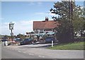
The Anchor, Runsell Green
Pub/restaurant.
Image: © John Myers
Taken: 1 Sep 2006
0.07 miles
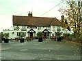
3
Former Saracen's Head pub
According to maps, this was a pub a long time ago, and more recently a residence called Wickham House. At some stage in its history it was tea rooms, as shown on the end wall. Now derelict or at least boarded up.
Image: © Robin Webster
Taken: 8 Dec 2012
0.12 miles
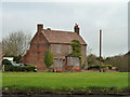
4
The old tea rooms, Runsell Green
A third shot for Geograph of this former public house/tea rooms/private dwelling, the last one being 18 months ago. Still boarded up and deteriorating slowly. What a waste!
Image: © Trevor Harris
Taken: 9 May 2014
0.12 miles
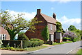
5
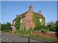
The Old Tea Rooms, Runsell Green
A derelict house such as this is a rare sight in this affluent area. I wonder what went wrong? (I suspect it hasn't been a Tea Room for many a decade). There is a faded sign painted on the east wall telling of its past.
Image: © Glyn Baker
Taken: 20 Aug 2005
0.15 miles
6
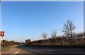
Chelmsford Road entering Woodham Mortimer
Image: © David Howard
Taken: 23 Feb 2019
0.25 miles