IMAGES TAKEN NEAR TO
Westerings, CHELMSFORD, CM3 4ND
Introduction
This page details the photographs taken nearby to Westerings, CM3 4ND by members of the Geograph project.
The Geograph project started in 2005 with the aim of publishing, organising and preserving representative images for every square kilometre of Great Britain, Ireland and the Isle of Man.

There are currently over 7.5m images from over14,400 individuals and you can help contribute to the project by visiting https://www.geograph.org.uk
Image Map
Images are licensed for reuse under creativecommons.org/licenses/by-sa/2.0
Notes
- Clicking on the map will re-center to the selected point.
- The higher the marker number, the further away the image location is from the centre of the postcode.
Image Listing (16 Images Found)
Images are licensed for reuse under creativecommons.org/licenses/by-sa/2.0
Image
Details
Distance
1
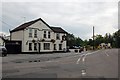
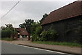
The White Swan, Bicknacre
Compare this to the geograph from Angela Tuff in 2006. Now the building is white, and the mural painting of the swan has gone - but at least the pub is still in operation.
Image: © Trevor Harris
Taken: 9 Jun 2009
0.11 miles
3
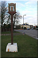
Bicknacre Village Sign
The sign is located on the Bicknacre Road near the junction of White Elm Road and Image
Image: © terry joyce
Taken: 7 Feb 2009
0.13 miles
4
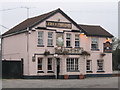
The White Swan
Public House, one of two in Bicknacre
Image: © Angela Tuff
Taken: 14 Jan 2006
0.14 miles
5
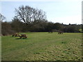
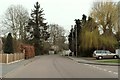
Priory Fields
This is part of what is called East Meadow on Priory Fields.
See http://www.prioryfields.org.uk
Image: © terry joyce
Taken: 17 Mar 2009
0.15 miles
6
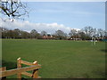
Priory Football Pitches
This is near to the entrance of Priory Fields looking back towards the car park that is next to Priory Primary School.
Image: © terry joyce
Taken: 17 Mar 2009
0.16 miles
8
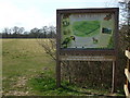
Welcome to Priory Fields
Priory Fields is located in the village of Bicknacre. It comprises around thirty two acres of meadowland, which includes the Priory Arch. This is the remains of Bicknacre Priory. Originally the fields belonged to the Priory. Part of the land became Priory Farm and when that was sold, seven acres of land and the arch were given to the parish.
Woodham Ferrers and Bicknacre Parish Council were instrumental in forming a volunteer group called the Friends of Priory Fields. They are responsible for developing and maintaining these peaceful surroundings for the benefit of the local and wider community. In 2007 they were able to purchase a further 25 acres, with the aid of a grant from the Heritage Lottery Fund.
Image: © terry joyce
Taken: 17 Mar 2009
0.18 miles
9
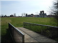
Bridge to the Priory
This bridge allows access to the field where the Priory Arch stands. There is a stream running under this bridge.
Image: © terry joyce
Taken: 17 Mar 2009
0.19 miles
10
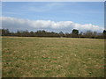
Priory Fields
This is part of Priory Fields called East Meadow.
See http://www.prioryfields.org.uk
Image: © terry joyce
Taken: 17 Mar 2009
0.19 miles