IMAGES TAKEN NEAR TO
Slough Road, CHELMSFORD, CM3 4LY
Introduction
This page details the photographs taken nearby to Slough Road, CM3 4LY by members of the Geograph project.
The Geograph project started in 2005 with the aim of publishing, organising and preserving representative images for every square kilometre of Great Britain, Ireland and the Isle of Man.

There are currently over 7.5m images from over14,400 individuals and you can help contribute to the project by visiting https://www.geograph.org.uk
Image Map (7 Images)


Getting Data...Please wait
Leaflet Map data © OpenStreetMap
Images are licensed for reuse under creativecommons.org/licenses/by-sa/2.0
Notes
- Clicking on the map will re-center to the selected point.
- The higher the marker number, the further away the image location is from the centre of the postcode.
Image Listing (7 Images Found)
Images are licensed for reuse under creativecommons.org/licenses/by-sa/2.0
Image
Details
Distance
1
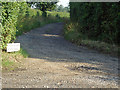
Looking down Wickham's Chase
Track leading from Slough Road to Wickham's Farm.
Image: © Roger Jones
Taken: 14 Jun 2011
0.02 miles
2

Wickham's Chase
A track to Wickham's Farm.
Image: © Robin Webster
Taken: 21 Jun 2014
0.03 miles
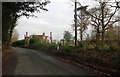
3
Cottages on Slough Lane
The one on the left had a 'Sold' sign outside.
Image: © Robin Webster
Taken: 1 Jun 2014
0.04 miles
4
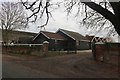
Barn conversions at Jacklett's Farm, Bicknacre
Image: © David Howard
Taken: 7 Dec 2019
0.10 miles
5
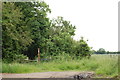
Footpath opposite Slough House Wood
From here it heads south east to Corporation Bridge, Cock Clarks.
Image: © Trevor Harris
Taken: 9 Jun 2014
0.17 miles
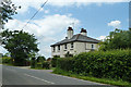
7
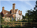
Slough House
Slough House, Danbury: As seen from Slough Road.
This is a listed building. See http://www.britishlistedbuildings.co.uk/en-112522-slough-house-danbury
Image: © Roger Jones
Taken: 14 Jun 2011
0.21 miles