IMAGES TAKEN NEAR TO
Horne Row, CHELMSFORD, CM3 4JN
Introduction
This page details the photographs taken nearby to Horne Row, CM3 4JN by members of the Geograph project.
The Geograph project started in 2005 with the aim of publishing, organising and preserving representative images for every square kilometre of Great Britain, Ireland and the Isle of Man.

There are currently over 7.5m images from over14,400 individuals and you can help contribute to the project by visiting https://www.geograph.org.uk
Image Map
Images are licensed for reuse under creativecommons.org/licenses/by-sa/2.0
Notes
- Clicking on the map will re-center to the selected point.
- The higher the marker number, the further away the image location is from the centre of the postcode.
Image Listing (28 Images Found)
Images are licensed for reuse under creativecommons.org/licenses/by-sa/2.0
Image
Details
Distance
1
Plumtre Lane - Danbury
Photograph taken from its junction with Horn Row. Continuing along this unmade road leads onto Bicknacre Road.
Image: © Malcolm Reid
Taken: 10 Jan 2007
0.06 miles
2
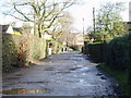
Horn Row - Danbury
Horn Row is an unmade road, shown here at its junction onto Bicknacre Road.
The house on the left, called Heathcote House, was the original home of Heathcote School.
Heathcote School is now located at Eves Corner in the centre of Danbury.
Image: © Malcolm Reid
Taken: 10 Jan 2007
0.07 miles
3
Danbury Common, Essex
A view south-east from Sporhams Lane. The house is on Horne Row.
Image: © John Winfield
Taken: 28 Jun 2006
0.07 miles
4
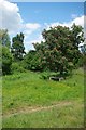
Seat on Danbury Common
Danbury Common http://www.wildessex.net/sites/Danbury%20Common.htm is managed by the National Trust http://www.nationaltrust.org.uk/main/w-danburycommonsandblakeswood
Image: © Glyn Baker
Taken: 20 May 2011
0.11 miles
5
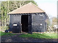
The Old Armoury - Danbury Common
The original 'Old' Armoury was built in 1802 as a military store to support troup stationed on Danbury Common at a time when an invasion by Napoleon was thought possible.
The original Armoury was destroyed by fire in 1996; this replica building is now used as a base for the National Trust Warden (Chelmsford District).
Image: © Malcolm Reid
Taken: 10 Jan 2007
0.14 miles
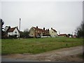
6
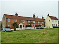
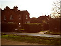
Houses, Danbury Common
The detached house is called 'The Old Stores'.
Image: © Robin Webster
Taken: 8 Dec 2012
0.14 miles
7
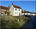
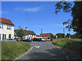
Penny Royal Road
Houses and the Cricketers Arms
Image: © John Myers
Taken: 15 Nov 2023
0.14 miles
8
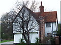
Poplars - Penny Royal Rd - Danbury
This old timber-framed house is thought to have originally been one of the buildings associated with a farm which lay to the north of Woodhill Road. Until the early 20th century this area was known as Horn Row.
Image: © Malcolm Reid
Taken: 29 Jan 2007
0.15 miles
9
The Cricketers Public House, Danbury Common
A popular country inn surrounded by National Trust common.
Image: © John Winfield
Taken: 28 Jun 2006
0.15 miles
10
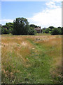
A quiet corner on Danbury Common
Almost all of Danbury Common is National Trust land.
Image: © John V Nicholls
Taken: 19 Jan 2006
0.15 miles