IMAGES TAKEN NEAR TO
Hammonds Road, CHELMSFORD, CM3 4BQ
Introduction
This page details the photographs taken nearby to Hammonds Road, CM3 4BQ by members of the Geograph project.
The Geograph project started in 2005 with the aim of publishing, organising and preserving representative images for every square kilometre of Great Britain, Ireland and the Isle of Man.

There are currently over 7.5m images from over14,400 individuals and you can help contribute to the project by visiting https://www.geograph.org.uk
Image Map (Loading...)


Getting Data...Please wait
Leaflet Map data © OpenStreetMap
Images are licensed for reuse under creativecommons.org/licenses/by-sa/2.0
Notes
- Clicking on the map will re-center to the selected point.
- The higher the marker number, the further away the image location is from the centre of the postcode.
Image Listing (4 Images Found)
Images are licensed for reuse under creativecommons.org/licenses/by-sa/2.0
Image
Details
Distance
1
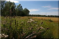
Fields south of the River Chelmer, near Boreham
The nearby willows mark the line of a drain along the southern edge of the flood-plain; the distant trees mark the line of the River Chelmer.
Image: © Christopher Hilton
Taken: 8 Jul 2017
0.22 miles
2
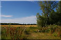
Fields south of the River Chelmer, near Boreham
The nearby trees mark the line of a drain along the southern edge of the flood-plain; the distant trees mark the line of the River Chelmer.
Image: © Christopher Hilton
Taken: 8 Jul 2017
0.24 miles
3
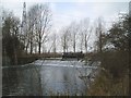
Stonhams Lock Weirpool
The narrow boat has passed through the lock and is heading upstream.
Image: © Paul Franks
Taken: 10 Mar 2012
0.25 miles
4
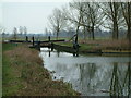
Chelmer and Blackwater Navigation
Stonham's Lock
Image: © Robin Lucas
Taken: 13 Feb 2015
0.25 miles