IMAGES TAKEN NEAR TO
Belsteads Farm Lane, CHELMSFORD, CM3 3PT
Introduction
This page details the photographs taken nearby to Belsteads Farm Lane, CM3 3PT by members of the Geograph project.
The Geograph project started in 2005 with the aim of publishing, organising and preserving representative images for every square kilometre of Great Britain, Ireland and the Isle of Man.

There are currently over 7.5m images from over14,400 individuals and you can help contribute to the project by visiting https://www.geograph.org.uk
Image Map
Images are licensed for reuse under creativecommons.org/licenses/by-sa/2.0
Notes
- Clicking on the map will re-center to the selected point.
- The higher the marker number, the further away the image location is from the centre of the postcode.
Image Listing (4 Images Found)
Images are licensed for reuse under creativecommons.org/licenses/by-sa/2.0
Image
Details
Distance
1
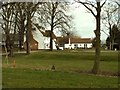
Channels Golf Club, Little Waltham, Essex
The building, in this picture, is 14th century and it became the Golf Clubhouse in 1974.
Image: © Robert Edwards
Taken: 19 Mar 2006
0.03 miles
2
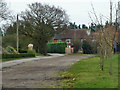
Blue Post Cottages
On Belstead Farm Lane, built 1912.
Image: © Robin Webster
Taken: 13 Jan 2013
0.21 miles
3
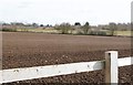
View South-east from the perimeter fence of Chelmer Valley park & Ride facility
Image: © Derek Voller
Taken: 3 Mar 2016
0.23 miles
4
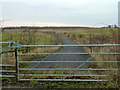
Gated road, disused
This is a comparatively recent creation, connecting Domsey Lane and Pratt's Farm Lane, but why it was built is not obvious.
Image: © Robin Webster
Taken: 13 Jan 2013
0.24 miles