IMAGES TAKEN NEAR TO
Blasford Hill, CHELMSFORD, CM3 3PL
Introduction
This page details the photographs taken nearby to Blasford Hill, CM3 3PL by members of the Geograph project.
The Geograph project started in 2005 with the aim of publishing, organising and preserving representative images for every square kilometre of Great Britain, Ireland and the Isle of Man.

There are currently over 7.5m images from over14,400 individuals and you can help contribute to the project by visiting https://www.geograph.org.uk
Image Map
Images are licensed for reuse under creativecommons.org/licenses/by-sa/2.0
Notes
- Clicking on the map will re-center to the selected point.
- The higher the marker number, the further away the image location is from the centre of the postcode.
Image Listing (14 Images Found)
Images are licensed for reuse under creativecommons.org/licenses/by-sa/2.0
Image
Details
Distance
1
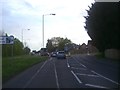
Blasford Hill at the junction of Hospital Approach
Image: © David Howard
Taken: 15 May 2012
0.04 miles
2
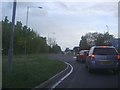
Blasford Hill at the junction of Hospital Approach
Turn right for Broomfield hospital
Image: © David Howard
Taken: 15 May 2012
0.07 miles
3
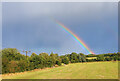
Rainbow near Broomfield
View towards Croxtons Mill.
Image: © Wayland Smith
Taken: 3 Oct 2021
0.13 miles
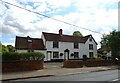
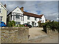
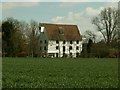
5
Wood House Lodge
This is curiously positioned on the other side of Woodhouse Lane from the main entrance to Wood House.
Image: © Robin Webster
Taken: 13 Jan 2013
0.19 miles
7
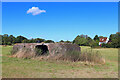
Pillbox near Broomfield
Abandoned fortification near Broomfield.
Image: © Wayland Smith
Taken: 3 Oct 2021
0.22 miles
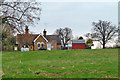
9
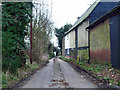
Woodhouse Lane
On the right are the outbuildings of Wood House.
Image: © Robin Webster
Taken: 13 Jan 2013
0.23 miles
10
Croxton's Mill, Essex
This old mill has recently been converted into offices. It stands near to Little Waltham Nature Reserve.
Image: © Robert Edwards
Taken: 5 Apr 2006
0.23 miles