IMAGES TAKEN NEAR TO
Boreham, CHELMSFORD, CM3 3HT
Introduction
This page details the photographs taken nearby to CM3 3HT by members of the Geograph project.
The Geograph project started in 2005 with the aim of publishing, organising and preserving representative images for every square kilometre of Great Britain, Ireland and the Isle of Man.

There are currently over 7.5m images from over14,400 individuals and you can help contribute to the project by visiting https://www.geograph.org.uk
Image Map (Loading...)


Getting Data...Please wait
Leaflet Map data © OpenStreetMap
Images are licensed for reuse under creativecommons.org/licenses/by-sa/2.0
Notes
- Clicking on the map will re-center to the selected point.
- The higher the marker number, the further away the image location is from the centre of the postcode.
Image Listing (6 Images Found)
Images are licensed for reuse under creativecommons.org/licenses/by-sa/2.0
Image
Details
Distance
1
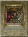
Henry VIII coat of arms in New Hall Chapel
Image: © Ken Brown
Taken: 8 Mar 2012
0.01 miles
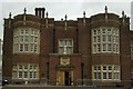
2
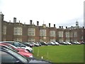
New Hall School
New Hall Catholic Independent boarding school. Founded in 1642 the building was originally the Tudor Palace of Beaulieu. The royal arms or Henry VIII is displayed in the chapel. Mary Tudor lived there for many years.
Image: © Ken Brown
Taken: 4 Mar 2011
0.02 miles
4
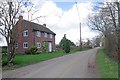
Generals Lane
The lane is actually a footpath near the junction of three rights of way.
Image: © Glyn Baker
Taken: 12 Mar 2020
0.18 miles
5
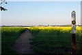
Footpath through the Rape
A very well cleared footpath route through a crop which otherwise is almost impassable at this stage of growth.
Image: © Robin Webster
Taken: 18 Apr 2007
0.20 miles
6
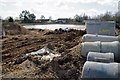
New Pond by Bulls Lodge Cottages
One of numerous lakes and ponds that are part of a major new development
Image: © Glyn Baker
Taken: 12 Mar 2020
0.23 miles