IMAGES TAKEN NEAR TO
Church Road, CHELMSFORD, CM3 2LE
Introduction
This page details the photographs taken nearby to Church Road, CM3 2LE by members of the Geograph project.
The Geograph project started in 2005 with the aim of publishing, organising and preserving representative images for every square kilometre of Great Britain, Ireland and the Isle of Man.

There are currently over 7.5m images from over14,400 individuals and you can help contribute to the project by visiting https://www.geograph.org.uk
Image Map
Images are licensed for reuse under creativecommons.org/licenses/by-sa/2.0
Notes
- Clicking on the map will re-center to the selected point.
- The higher the marker number, the further away the image location is from the centre of the postcode.
Image Listing (37 Images Found)
Images are licensed for reuse under creativecommons.org/licenses/by-sa/2.0
Image
Details
Distance
1
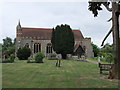
The ancient priory church of St. Andrew, Hatfield Peverel
The church is the surviving fragment of the Norman priory church nave built c1130
Image: © PAUL FARMER
Taken: 31 May 2010
0.06 miles
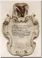
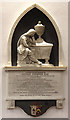
3
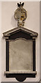
St Andrew, Hatfield Peverel - Wall monument
Image: © John Salmon
Taken: 8 Oct 2013
0.07 miles
5
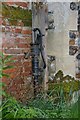
Parish Pump
This pump is in the churchyard against the wall of Image
Image: © Glyn Baker
Taken: 15 Apr 2006
0.07 miles

7
St Andrew, Hatfield Peverel - Wall monument
Image: © John Salmon
Taken: 8 Oct 2013
0.07 miles
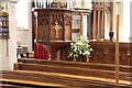
8
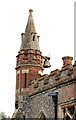
St Andrew, Hatfield Peverel - Bell turret
Image: © John Salmon
Taken: 8 Oct 2013
0.07 miles
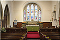
9
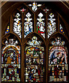
St Andrew, Hatfield Peverel - Stained glass window
Image: © John Salmon
Taken: 8 Oct 2013
0.08 miles
10
St Andrew, Hatfield Peverel - Wall monument
Image: © John Salmon
Taken: 8 Oct 2013
0.08 miles