IMAGES TAKEN NEAR TO
The Street, CHELMSFORD, CM3 2DR
Introduction
This page details the photographs taken nearby to The Street, CM3 2DR by members of the Geograph project.
The Geograph project started in 2005 with the aim of publishing, organising and preserving representative images for every square kilometre of Great Britain, Ireland and the Isle of Man.

There are currently over 7.5m images from over14,400 individuals and you can help contribute to the project by visiting https://www.geograph.org.uk
Image Map
Images are licensed for reuse under creativecommons.org/licenses/by-sa/2.0
Notes
- Clicking on the map will re-center to the selected point.
- The higher the marker number, the further away the image location is from the centre of the postcode.
Image Listing (26 Images Found)
Images are licensed for reuse under creativecommons.org/licenses/by-sa/2.0
Image
Details
Distance
4
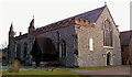
St Andrew's Church, Hatfield Peverel, Essex.
Image: © Peter Stack
Taken: 14 Jan 2009
0.06 miles

8
Old Cast Iron Milepost
Old cast iron milepost at Hatfield Peverel, Essex. For close up view see http://www.geograph.org.uk/photo/4312828
Image: © Keith Evans
Taken: 11 Dec 2014
0.09 miles
9
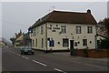
The Swan Inn Hatfield Peverel
For once the term “Inn” is not just a historical name. This Free House still advertises rooms available.
Image: © Glyn Baker
Taken: 15 Apr 2006
0.10 miles
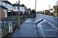
10
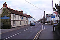
The Street, Hatfield Peverel, Essex
The Blue Strawberry restaurant and The Swan Inn are on the left of the photo.
Image: © Peter Stack
Taken: 29 Feb 2012
0.11 miles