IMAGES TAKEN NEAR TO
Fairstead, CHELMSFORD, CM3 2BH
Introduction
This page details the photographs taken nearby to CM3 2BH by members of the Geograph project.
The Geograph project started in 2005 with the aim of publishing, organising and preserving representative images for every square kilometre of Great Britain, Ireland and the Isle of Man.

There are currently over 7.5m images from over14,400 individuals and you can help contribute to the project by visiting https://www.geograph.org.uk
Image Map
Images are licensed for reuse under creativecommons.org/licenses/by-sa/2.0
Notes
- Clicking on the map will re-center to the selected point.
- The higher the marker number, the further away the image location is from the centre of the postcode.
Image Listing (5 Images Found)
Images are licensed for reuse under creativecommons.org/licenses/by-sa/2.0
Image
Details
Distance
1
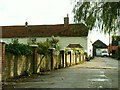
Blixes Farm
The road leads to Blixes Farm and its farm shop, but the row of cottages in the picture don't seem to be part of the farm.
Image: © Robert Edwards
Taken: 6 Oct 2006
0.04 miles
2
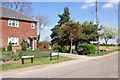
The last Hazelton Cottage in Rank's Green
What decides the definitive punctuation of a place or road? This place is Rank's Green on the OS maps, but the road name sign says Ranks Green Road. The cottages are surely Hazelton Cottages, but the sign calls them Cotts.
Image: © Robin Webster
Taken: 18 Apr 2007
0.12 miles
4
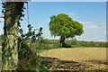
Footpath, Rank's Green
The footpath doglegs its way to Dagnets Farm.
Image: © Robin Webster
Taken: 18 Apr 2007
0.22 miles
5
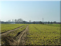
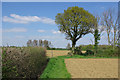
A growing crop
A field of a young cereal, probably wheat.
Image: © Robin Webster
Taken: 5 Mar 2013
0.22 miles