IMAGES TAKEN NEAR TO
Hatfield Road, CHELMSFORD, CM3 2AN
Introduction
This page details the photographs taken nearby to Hatfield Road, CM3 2AN by members of the Geograph project.
The Geograph project started in 2005 with the aim of publishing, organising and preserving representative images for every square kilometre of Great Britain, Ireland and the Isle of Man.

There are currently over 7.5m images from over14,400 individuals and you can help contribute to the project by visiting https://www.geograph.org.uk
Image Map (Loading...)


Getting Data...Please wait
Leaflet Map data © OpenStreetMap
Images are licensed for reuse under creativecommons.org/licenses/by-sa/2.0
Notes
- Clicking on the map will re-center to the selected point.
- The higher the marker number, the further away the image location is from the centre of the postcode.
Image Listing (5 Images Found)
Images are licensed for reuse under creativecommons.org/licenses/by-sa/2.0
Image
Details
Distance
1
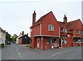
Terling Stores
The building dates from C14 and was altered in the C16 and C20. See http://www.britishlistedbuildings.co.uk/en-115472-terling-stores-and-post-office-terling-e#.Vc23QvlViko for entry in British Listed Buildings.
Image: © Bikeboy
Taken: 11 Aug 2015
0.23 miles
2
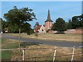
Terling Church, Essex
The church viewed from the coach meadow.
Image: © Robert Palmer
Taken: 1 Jul 2006
0.23 miles
3

All Saints Parish Church, Terling, Essex.
Image: © Peter Stack
Taken: 14 Jan 2009
0.23 miles
4
Terling Post Office
Also titled 'The Terling Stores'.
Image: © Robin Webster
Taken: 13 Jan 2013
0.23 miles
5
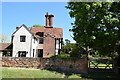
Tudor House
On the green at Terling beside the church.
Image: © Trevor Harris
Taken: 19 May 2020
0.24 miles