IMAGES TAKEN NEAR TO
Kay Close, CHELMSFORD, CM3 1RU
Introduction
This page details the photographs taken nearby to Kay Close, CM3 1RU by members of the Geograph project.
The Geograph project started in 2005 with the aim of publishing, organising and preserving representative images for every square kilometre of Great Britain, Ireland and the Isle of Man.

There are currently over 7.5m images from over14,400 individuals and you can help contribute to the project by visiting https://www.geograph.org.uk
Image Map (Loading...)


Getting Data...Please wait
Leaflet Map data © OpenStreetMap
Images are licensed for reuse under creativecommons.org/licenses/by-sa/2.0
Notes
- Clicking on the map will re-center to the selected point.
- The higher the marker number, the further away the image location is from the centre of the postcode.
Image Listing (8 Images Found)
Images are licensed for reuse under creativecommons.org/licenses/by-sa/2.0
Image
Details
Distance
1
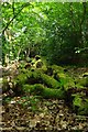
Sandlay Wood Pile
This log pile in Image has clearly been around for a while. http://www.essexwt.org.uk/visitor_centres__nature_reserves/sandylay/ this home for invertebrates was in Sandlay Wood.
Image: © Glyn Baker
Taken: 16 May 2009
0.16 miles
3
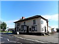
St Anne's Castle, Great Leighs
The pub stands on the site of a Hermitage which was a stopping point for pilgrims on their way to Canterbury. At the time of the dissolution of the monasteries it was given to a Thomas Jennings. Ogilby's map of 1675 shows that an inn was present on this site at this time. The current building is C19. See http://www.britishlistedbuildings.co.uk/en-112655-st-anne-s-castle-inn-great-and-little-le for details.
Image: © Bikeboy
Taken: 11 Oct 2014
0.22 miles
4
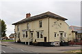
The Castle Inn, Great Leighs
Formerly St. Annes Castle.
Claims to be the oldest licensed establishment in Britain - from circa 1171. The actual building is a mere one hundred years old due to a fire.
For the record. The Bingley Arms, Bardsey, near Leeds claims to have been pulling pints since AD 905, well before William the Bastard's invasion of 1066.
Image: © Chris Heaton
Taken: 3 Oct 2018
0.23 miles
5
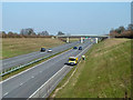
Collecting litter on the A131
The bridges over this fairly new section of the A131 all have names. This one, a footbridge, is Chase Side Bridge.
Image: © Robin Webster
Taken: 5 Mar 2013
0.23 miles
7
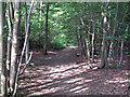
Path in Moat Wood
Moat Wood is part of the Essex Wildlife Trust's Sandylay and Moat Woods Nature Reserve. They were donated to the Trust in 1982 by the late Mr Roland Adams and Mrs Adams.
Essex Wildlife Trust: http://www.essexwt.org.uk/reserves/sandylay-moat-woods
Wild Essex: http://www.wildessex.net/sites/Sandylay%20Moat%20Woods.htm
Image: © Roger Jones
Taken: 22 Jun 2014
0.25 miles
8
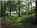
The edge of Sandylay Wood
Sandylay Wood is part of the Essex Wildlife Trust's Sandylay and Moat Woods Nature Reserve. They were donated to the Trust in 1982 by the late Mr Roland Adams and Mrs Adams.
Essex Wildlife Trust: http://www.essexwt.org.uk/reserves/sandylay-moat-woods
Wild Essex: http://www.wildessex.net/sites/Sandylay%20Moat%20Woods.htm
Image: © Roger Jones
Taken: 22 Jun 2014
0.25 miles