IMAGES TAKEN NEAR TO
Church Lane, CHELMSFORD, CM3 1PG
Introduction
This page details the photographs taken nearby to Church Lane, CM3 1PG by members of the Geograph project.
The Geograph project started in 2005 with the aim of publishing, organising and preserving representative images for every square kilometre of Great Britain, Ireland and the Isle of Man.

There are currently over 7.5m images from over14,400 individuals and you can help contribute to the project by visiting https://www.geograph.org.uk
Image Map
Images are licensed for reuse under creativecommons.org/licenses/by-sa/2.0
Notes
- Clicking on the map will re-center to the selected point.
- The higher the marker number, the further away the image location is from the centre of the postcode.
Image Listing (3 Images Found)
Images are licensed for reuse under creativecommons.org/licenses/by-sa/2.0
Image
Details
Distance
1
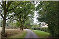
Approaching Sweetings Farm on Church Lane
Image: © Tim Heaton
Taken: 18 Oct 2023
0.13 miles
2
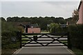
Sweetings Farm
Farm off Church Lane near Little Leighs
Image: © Chris Heaton
Taken: 18 Oct 2023
0.13 miles
3
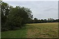
Footpath heading South West off Church Lane
Countryside beside Little Warricks - the footpath following the vegetation beside the field boundary
Image: © Chris Heaton
Taken: 18 Oct 2023
0.19 miles