IMAGES TAKEN NEAR TO
The Crescent, CHELMSFORD, CM3 1LY
Introduction
This page details the photographs taken nearby to The Crescent, CM3 1LY by members of the Geograph project.
The Geograph project started in 2005 with the aim of publishing, organising and preserving representative images for every square kilometre of Great Britain, Ireland and the Isle of Man.

There are currently over 7.5m images from over14,400 individuals and you can help contribute to the project by visiting https://www.geograph.org.uk
Image Map
Images are licensed for reuse under creativecommons.org/licenses/by-sa/2.0
Notes
- Clicking on the map will re-center to the selected point.
- The higher the marker number, the further away the image location is from the centre of the postcode.
Image Listing (8 Images Found)
Images are licensed for reuse under creativecommons.org/licenses/by-sa/2.0
Image
Details
Distance

5
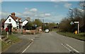
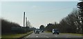
A corner of Little Leighs
This road was once part of the busy A.131, which now has a new bypass, and it is also on the course of a Roman road. The road off to the left leads to the parish church.
Image: © Robert Edwards
Taken: 9 Apr 2007
0.17 miles
6
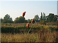
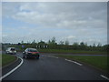
Orange Ladybirds, Great Leighs
This modern sculpture of three metal bugs climbing metal blades of grass can be seen at the side of the new A131 Great Leighs By-Pass, Essex. Travelling north, towards Braintree, directly before the Rochester Farm Bridge, look to the left and there they can be seen standing about 4m tall!
Image: © Brenda Howard
Taken: 15 Oct 2005
0.22 miles
8
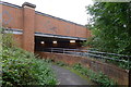
The Essex Way passing underneath the A131
Sharing the underpass with the River Ter and another footpath
Image: © Tim Heaton
Taken: 3 Oct 2018
0.24 miles