IMAGES TAKEN NEAR TO
Acreland Green, CHELMSFORD, CM3 1HP
Introduction
This page details the photographs taken nearby to Acreland Green, CM3 1HP by members of the Geograph project.
The Geograph project started in 2005 with the aim of publishing, organising and preserving representative images for every square kilometre of Great Britain, Ireland and the Isle of Man.

There are currently over 7.5m images from over14,400 individuals and you can help contribute to the project by visiting https://www.geograph.org.uk
Image Map
Images are licensed for reuse under creativecommons.org/licenses/by-sa/2.0
Notes
- Clicking on the map will re-center to the selected point.
- The higher the marker number, the further away the image location is from the centre of the postcode.
Image Listing (8 Images Found)
Images are licensed for reuse under creativecommons.org/licenses/by-sa/2.0
Image
Details
Distance
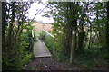
1
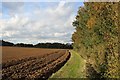
Field at Acreland Green
The public footpath heading north towards the Essex Way, appears to be on this side of the hedgerow
Image: © Chris Heaton
Taken: 2 Oct 2018
0.07 miles
3
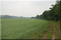
The Essex Way 47 and a bit!
Missed this one when uploading. The Essex Way skirts (muddily) a field planted with peas north of Acreland Green.
Image: © Trevor Harris
Taken: 6 Jun 2010
0.17 miles
4
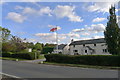
Live stock sheds at Wheats Farm
Marked as a poultry farm on the O.S. map.
Image: © Bikeboy
Taken: 11 Oct 2014
0.20 miles
5
Footpath to Upper Harveys branching off from the Essex Way
Image: © Tim Heaton
Taken: 3 Oct 2018
0.20 miles
6
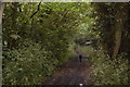
The Essex Way 47
The path follows a shady bridleway out of Stagden Cross.
Image: © Trevor Harris
Taken: 6 Jun 2010
0.23 miles
7
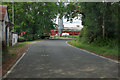
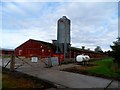
Corner by Wheats Farm
This is mapped as a poultry farm, which still looks the case.
Image: © Robin Webster
Taken: 15 Sep 2011
0.23 miles
8
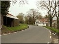
Part of Wheats Farm
The road is known as The Street.
Image: © Robert Edwards
Taken: 25 Apr 2008
0.23 miles