IMAGES TAKEN NEAR TO
Bramley Place, CHELMSFORD, CM2 9TH
Introduction
This page details the photographs taken nearby to Bramley Place, CM2 9TH by members of the Geograph project.
The Geograph project started in 2005 with the aim of publishing, organising and preserving representative images for every square kilometre of Great Britain, Ireland and the Isle of Man.

There are currently over 7.5m images from over14,400 individuals and you can help contribute to the project by visiting https://www.geograph.org.uk
Image Map (Loading...)


Getting Data...Please wait
Leaflet Map data © OpenStreetMap
Images are licensed for reuse under creativecommons.org/licenses/by-sa/2.0
Notes
- Clicking on the map will re-center to the selected point.
- The higher the marker number, the further away the image location is from the centre of the postcode.
Image Listing (7 Images Found)
Images are licensed for reuse under creativecommons.org/licenses/by-sa/2.0
Image
Details
Distance
2
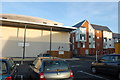
Marconi Social Club
Part of the club building with flats behind it.
Image: © Trevor Harris
Taken: 8 Mar 2014
0.12 miles
3
Rothmans Avenue meets Dorset Avenue
A signed cycle route to the 'Town Centre' turns right here. The town is presumably Chelmsford, as Great Baddow is more of a suburban village.
Image: © Robin Webster
Taken: 11 Dec 2012
0.20 miles
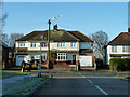
5
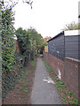
Public Footpath near Loftin Way, Chelmsford
Image: © Roger Jones
Taken: 4 Nov 2018
0.23 miles
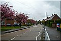
6
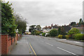
Baddow Road
Part of a more established residential area surrounding Chelmsford, looking in the direction of the city centre.
Image: © Bill Boaden
Taken: 2 Sep 2019
0.24 miles
7
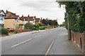
Baddow Road
Part of an established residential area surrounding Chelmsford. The telegraph pole really does lean out.
Image: © Bill Boaden
Taken: 2 Sep 2019
0.25 miles