IMAGES TAKEN NEAR TO
Moulsham Drive, CHELMSFORD, CM2 9PX
Introduction
This page details the photographs taken nearby to Moulsham Drive, CM2 9PX by members of the Geograph project.
The Geograph project started in 2005 with the aim of publishing, organising and preserving representative images for every square kilometre of Great Britain, Ireland and the Isle of Man.

There are currently over 7.5m images from over14,400 individuals and you can help contribute to the project by visiting https://www.geograph.org.uk
Image Map
Images are licensed for reuse under creativecommons.org/licenses/by-sa/2.0
Notes
- Clicking on the map will re-center to the selected point.
- The higher the marker number, the further away the image location is from the centre of the postcode.
Image Listing (7 Images Found)
Images are licensed for reuse under creativecommons.org/licenses/by-sa/2.0
Image
Details
Distance
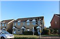
2
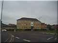
Flats on Burghley Way, Moulsham
At the junction of Princes Road
Image: © David Howard
Taken: 2 May 2012
0.09 miles
4
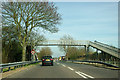
Footbridge over A1114, Princes Road
The road was formerly the A12 and the first attempt at a Chelmsford bypass.
Image: © Robin Webster
Taken: 25 Mar 2012
0.19 miles
6
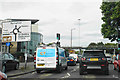
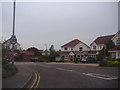
Queuing to get on the Army & Navy Roundabout
This approach is from Van Diemans Road, part of the A1114.
Image: © Bill Boaden
Taken: 2 Sep 2019
0.23 miles
7
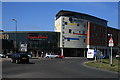
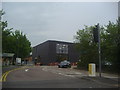
The Army and Navy
New development on the site of the Army and Navy pub.
Image: © Paul Franks
Taken: 1 Apr 2012
0.24 miles