IMAGES TAKEN NEAR TO
Alder Drive, CHELMSFORD, CM2 9EY
Introduction
This page details the photographs taken nearby to Alder Drive, CM2 9EY by members of the Geograph project.
The Geograph project started in 2005 with the aim of publishing, organising and preserving representative images for every square kilometre of Great Britain, Ireland and the Isle of Man.

There are currently over 7.5m images from over14,400 individuals and you can help contribute to the project by visiting https://www.geograph.org.uk
Image Map
Images are licensed for reuse under creativecommons.org/licenses/by-sa/2.0
Notes
- Clicking on the map will re-center to the selected point.
- The higher the marker number, the further away the image location is from the centre of the postcode.
Image Listing (5 Images Found)
Images are licensed for reuse under creativecommons.org/licenses/by-sa/2.0
Image
Details
Distance
1
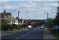
Longstomps Avenue
Looking downhill towards Oaklands Park, Chelmsford College and the city centre.
Image: © Paul Franks
Taken: 15 Apr 2012
0.17 miles
2
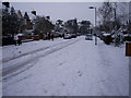
Longstomps Avenue, Chelmsford
Following a heavy snow fall
Image: © Arthur Stevens
Taken: 2 Feb 2009
0.23 miles
3
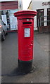
Elizabeth II postbox on Wood Street, Chelmsford
Postbox No. CM2 273.
See Image] for context.
Image: © JThomas
Taken: 11 May 2019
0.24 miles
4
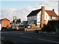
'The Eagle & Hind' public house
This pub stands in Gloucester Avenue.
Image: © Robert Edwards
Taken: 19 Feb 2010
0.24 miles
5
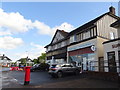
Shops on Wood Street, Chelmsford
Showing position of Postbox No. CM2 273.
See Image] for postbox.
Image: © JThomas
Taken: 11 May 2019
0.24 miles