IMAGES TAKEN NEAR TO
Middlemead, CHELMSFORD, CM2 8UT
Introduction
This page details the photographs taken nearby to Middlemead, CM2 8UT by members of the Geograph project.
The Geograph project started in 2005 with the aim of publishing, organising and preserving representative images for every square kilometre of Great Britain, Ireland and the Isle of Man.

There are currently over 7.5m images from over14,400 individuals and you can help contribute to the project by visiting https://www.geograph.org.uk
Image Map
Images are licensed for reuse under creativecommons.org/licenses/by-sa/2.0
Notes
- Clicking on the map will re-center to the selected point.
- The higher the marker number, the further away the image location is from the centre of the postcode.
Image Listing (12 Images Found)
Images are licensed for reuse under creativecommons.org/licenses/by-sa/2.0
Image
Details
Distance
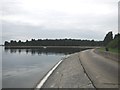
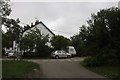
2
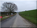
Long Road
This is Middlemead a road skirting the northern and part of the eastern side of Hanningfield Reservoir. The signs and fences to the left are a new housing development of 15 houses by Hastoe Housing Association.
Image: © terry joyce
Taken: 29 Jan 2011
0.15 miles
3

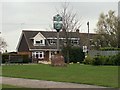
The Three Compasses, West Hanningfield
An attractive freehouse.
Image: © Trevor Harris
Taken: 6 Jun 2009
0.19 miles
4
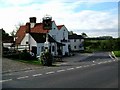
Three Compasses West Hanningfield
The Three Compasses West Hanningfield is a free house that stands on the Junction of Holliday Hill and Lower Stock Road. The photo was taken from Holliday Hill looking south west.
Image: © Glyn Baker
Taken: 5 Nov 2005
0.20 miles
5
"The Three Compasses", West Hanningfield
Image: © Neil Theasby
Taken: 11 Apr 2015
0.20 miles
6
Middlemead Bay, Hanningfield Reservoir
A solitary fishing boat in the bay on a calm afternoon.
Image: © Paul Franks
Taken: 1 Jun 2012
0.21 miles
7
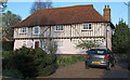
Gascoignes Farmhouse, West Hanningfield (Listed Building)
Gascoignes Farmhouse, Listed Building Grade: II.
List Entry Number: 1236873 https://historicengland.org.uk/listing/the-list/list-entry/1236873
A timber-framed and plastered house built between 1490 and 1540. Restored and altered in the C20. 2 storeys. The upper storey is jettied on the whole front, supported on brackets and with exposed timber framing. the windows are mainly C20 casements.
Image: © Roger Jones
Taken: 24 Mar 2019
0.21 miles
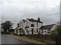
8
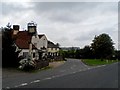
The Three Compasses pub, West Hanningfield
The earliest parts o the building date from C15. See entry in British Listed Buildings http://www.britishlistedbuildings.co.uk/en-428755-the-three-compasses-public-house-west-ha
Image: © Bikeboy
Taken: 13 Sep 2014
0.22 miles
9
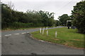
Holiday Hill at the junction of Lower Stock Road
Image: © David Howard
Taken: 4 Jul 2020
0.22 miles
10
Pynning's Farm Lane, West Hanningfield
Image: © David Howard
Taken: 4 Jul 2020
0.24 miles