IMAGES TAKEN NEAR TO
Mill Hill, CHELMSFORD, CM2 8TW
Introduction
This page details the photographs taken nearby to Mill Hill, CM2 8TW by members of the Geograph project.
The Geograph project started in 2005 with the aim of publishing, organising and preserving representative images for every square kilometre of Great Britain, Ireland and the Isle of Man.

There are currently over 7.5m images from over14,400 individuals and you can help contribute to the project by visiting https://www.geograph.org.uk
Image Map
Images are licensed for reuse under creativecommons.org/licenses/by-sa/2.0
Notes
- Clicking on the map will re-center to the selected point.
- The higher the marker number, the further away the image location is from the centre of the postcode.
Image Listing (10 Images Found)
Images are licensed for reuse under creativecommons.org/licenses/by-sa/2.0
Image
Details
Distance
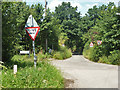
1
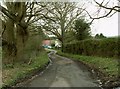
A dead-end country lane called Mill Hill
Image: © Robert Edwards
Taken: 31 Mar 2008
0.06 miles
2
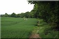
Bridleway Parallel to Margaretting Rd
Looking towards the A12
Image: © Glyn Baker
Taken: 22 May 2016
0.13 miles
4
Bridleway to Margaretting Rd
The path runs between Galleywood Common and Margaretting Rd near the A12 flyover
Image: © Glyn Baker
Taken: 22 May 2016
0.15 miles
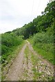
5
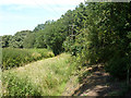
Bridleway along edge of Galleywood Common
A bank and ditch separates the track from the wooded common. The hedge is beyond the track, which is here mostly hidden by the vegetation along the ditch.
Image: © Robin Webster
Taken: 22 Jul 2012
0.16 miles
6
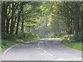
London Hill
Looking down London Hill as we leave Galleywood Common heading towards Margaretting
Image: © Andrew Pickess
Taken: 3 Sep 2005
0.19 miles
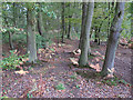
7
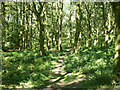
Path, Galleywood Common
The northern part of the common is largely wooded.
Image: © Robin Webster
Taken: 22 Jul 2012
0.21 miles
8
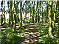
Path, Galleywood Common
The northern part of the common is largely wooded.
Image: © Robin Webster
Taken: 22 Jul 2012
0.21 miles
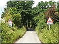
9
Crossroads, Galleywood
Straight on is a private road leading to a considerable number of houses. It is a public footpath, a way to Hylands Park.
Image: © Robin Webster
Taken: 22 Jul 2012
0.22 miles
10
Private road, Galleywood
This leads to a considerable number of houses. It is a public footpath, a way to Hylands Park.
Image: © Robin Webster
Taken: 22 Jul 2012
0.24 miles