IMAGES TAKEN NEAR TO
Private Road, CHELMSFORD, CM2 8TH
Introduction
This page details the photographs taken nearby to Private Road, CM2 8TH by members of the Geograph project.
The Geograph project started in 2005 with the aim of publishing, organising and preserving representative images for every square kilometre of Great Britain, Ireland and the Isle of Man.

There are currently over 7.5m images from over14,400 individuals and you can help contribute to the project by visiting https://www.geograph.org.uk
Image Map (7 Images)


Leaflet Map data © OpenStreetMap
Images are licensed for reuse under creativecommons.org/licenses/by-sa/2.0
Notes
- Clicking on the map will re-center to the selected point.
- The higher the marker number, the further away the image location is from the centre of the postcode.
Image Listing (7 Images Found)
Images are licensed for reuse under creativecommons.org/licenses/by-sa/2.0
Image
Details
Distance
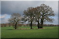
1
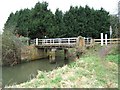
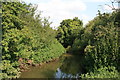
Bridge on the River Wid
This Bridge carries a footpath & private road over the River Wid southwest of Chelmsford. The photo was taken looking upstream
Image: © Glyn Baker
Taken: 24 Feb 2006
0.11 miles
2
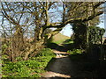
Green Lane
The lane is a public footpath running between Goat Hall Lane and Butts Way.
Image: © Paul Franks
Taken: 30 Mar 2021
0.12 miles
4
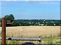
View north-west from Goat Hall Lane
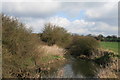
Looking over the valley of the River Wid towards Hylands Park.
Image: © Robin Webster
Taken: 22 Jul 2012
0.18 miles
5
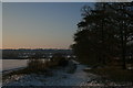
Winter Afternoon
The footpath between Goat Hall Lane and Butts Way. Hylands House is in the distance.
Image: © Paul Franks
Taken: 11 Feb 2012
0.21 miles