IMAGES TAKEN NEAR TO
Beehive Lane, CHELMSFORD, CM2 8RL
Introduction
This page details the photographs taken nearby to Beehive Lane, CM2 8RL by members of the Geograph project.
The Geograph project started in 2005 with the aim of publishing, organising and preserving representative images for every square kilometre of Great Britain, Ireland and the Isle of Man.

There are currently over 7.5m images from over14,400 individuals and you can help contribute to the project by visiting https://www.geograph.org.uk
Image Map (Loading...)


Getting Data...Please wait
Leaflet Map data © OpenStreetMap
Images are licensed for reuse under creativecommons.org/licenses/by-sa/2.0
Notes
- Clicking on the map will re-center to the selected point.
- The higher the marker number, the further away the image location is from the centre of the postcode.
Image Listing (8 Images Found)
Images are licensed for reuse under creativecommons.org/licenses/by-sa/2.0
Image
Details
Distance
2
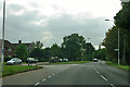
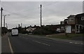
Beehive Lane at Skinners Lane junction
Beehive Lane makes a bee line for Galleywood church.
Image: © Robin Webster
Taken: 15 Sep 2011
0.17 miles
3
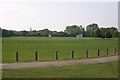
Chelmer Park
View across the park towards the church of St. Michael in the distance.
Image: © Andrew Pickess
Taken: 3 Sep 2005
0.20 miles
4
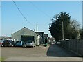
Chelmsford Equestrian Centre
The Centre offers riding lessons for all abilities, and its facilities include indoor and outdoor arenas, and a cross country course. Despite the 'Keep Out' sign on the gate, there is a public footpath through the site.
Image: © Paul Franks
Taken: 30 Mar 2021
0.21 miles
5
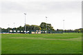
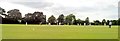
Looking to sports ground in Chelmer Park, Chelmsford
Image: © Roger Jones
Taken: 26 Sep 2015
0.22 miles
6
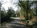
Slade's Lane
The lane runs between Beehive Lane and Stock Road/Galleywood Road.
Image: © Paul Franks
Taken: 30 Mar 2021
0.23 miles
8
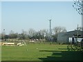
Chelmsford Equestrian Centre
The photograph shows the indoor and outdoor arenas, and part of the cross country course.
Image: © Paul Franks
Taken: 30 Mar 2021
0.25 miles