IMAGES TAKEN NEAR TO
Well Lane, CHELMSFORD, CM2 8QZ
Introduction
This page details the photographs taken nearby to Well Lane, CM2 8QZ by members of the Geograph project.
The Geograph project started in 2005 with the aim of publishing, organising and preserving representative images for every square kilometre of Great Britain, Ireland and the Isle of Man.

There are currently over 7.5m images from over14,400 individuals and you can help contribute to the project by visiting https://www.geograph.org.uk
Image Map
Images are licensed for reuse under creativecommons.org/licenses/by-sa/2.0
Notes
- Clicking on the map will re-center to the selected point.
- The higher the marker number, the further away the image location is from the centre of the postcode.
Image Listing (11 Images Found)
Images are licensed for reuse under creativecommons.org/licenses/by-sa/2.0
Image
Details
Distance
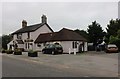
1
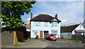
Blue house on Stock Road, Galleywood, Chelmsford
Image: © JThomas
Taken: 11 May 2019
0.19 miles
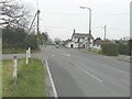
3
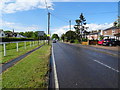
Stock Road, Galleywood , Chelmsford
Looking north on the B1007.
Image: © JThomas
Taken: 11 May 2019
0.22 miles
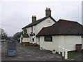
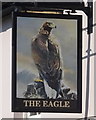
4
The Eagle, Galleywood, Chelmsford
On Stock Road.
Image: © JThomas
Taken: 11 May 2019
0.23 miles
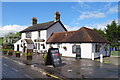
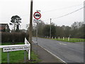
7
Crossroads at Galleywood
Seen from Margaretting Road, the main road is Stock Road (B1007) with Watchouse Road beyond.
Image: © John Baker
Taken: 28 Mar 2014
0.23 miles
8
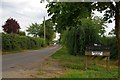
Road to Parklands Farm
A quick Google reveals that Parklands Farm is home to a number of industrial units.
Image: © Glyn Baker
Taken: 6 Aug 2006
0.24 miles
10

Sunset over Galleywood Common
Looking across the old race course on Galleywood Common which is no longer there,
Image: © Andrew Pickess
Taken: 14 Mar 2005
0.25 miles