IMAGES TAKEN NEAR TO
Vale End, CHELMSFORD, CM2 8NZ
Introduction
This page details the photographs taken nearby to Vale End, CM2 8NZ by members of the Geograph project.
The Geograph project started in 2005 with the aim of publishing, organising and preserving representative images for every square kilometre of Great Britain, Ireland and the Isle of Man.

There are currently over 7.5m images from over14,400 individuals and you can help contribute to the project by visiting https://www.geograph.org.uk
Image Map
Images are licensed for reuse under creativecommons.org/licenses/by-sa/2.0
Notes
- Clicking on the map will re-center to the selected point.
- The higher the marker number, the further away the image location is from the centre of the postcode.
Image Listing (5 Images Found)
Images are licensed for reuse under creativecommons.org/licenses/by-sa/2.0
Image
Details
Distance
1
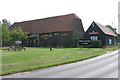
Seabrights Barn Galleywood
An old Essex Barn that was converted in the early 90's into a pub and restaurant.
Image: © Andrew Pickess
Taken: 3 Sep 2005
0.08 miles
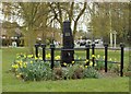
3
Old Milestone by Galleyend, Galleywood parish
Carved stone post by the UC road, in parish of GALLEYWOOD (CHELMSFORD District), Galleyend, on bend 50m Northeast of Watchouse Road/Brook Lane junction, on the verge, on East side of road. Erected by an unknown authority in the 19th century.
Inscription reads:-
LONDON
28
Milestone Society National ID: EX_MGMN28.
Image: © JV Nicholls
Taken: 25 Feb 2011
0.18 miles
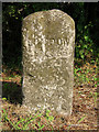
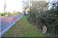
4
Old Milestone
Old milestone near to Galleywood, Essex for overall view see http://www.geograph.org.uk/photo/4312919
Image: © Keith Evans
Taken: 11 Dec 2014
0.19 miles
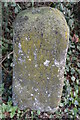
5
Old Milestone
Old milestone near to Galleywood, Essex for close up view see http://www.geograph.org.uk/photo/4312914
Image: © Keith Evans
Taken: 11 Dec 2014
0.20 miles