IMAGES TAKEN NEAR TO
Templeton Park, Bakers Lane, CHELMSFORD, CM2 8LG
Introduction
This page details the photographs taken nearby to Templeton Park, Bakers Lane, CM2 8LG by members of the Geograph project.
The Geograph project started in 2005 with the aim of publishing, organising and preserving representative images for every square kilometre of Great Britain, Ireland and the Isle of Man.

There are currently over 7.5m images from over14,400 individuals and you can help contribute to the project by visiting https://www.geograph.org.uk
Image Map
Images are licensed for reuse under creativecommons.org/licenses/by-sa/2.0
Notes
- Clicking on the map will re-center to the selected point.
- The higher the marker number, the further away the image location is from the centre of the postcode.
Image Listing (3 Images Found)
Images are licensed for reuse under creativecommons.org/licenses/by-sa/2.0
Image
Details
Distance
1
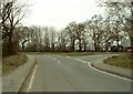
Road junction near Galleywood
This is where Baker's Lane meets the B1007.
Image: © Robert Edwards
Taken: 25 Mar 2008
0.17 miles
2
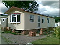
Mobile home, Temple Grove Caravan Park
Image: © Alex McGregor
Taken: 8 Jun 2011
0.19 miles
3
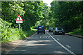
B1007 Stock Road
Heading towards Chelmsford.
Image: © Robin Webster
Taken: 22 Jul 2012
0.19 miles