IMAGES TAKEN NEAR TO
Linnet Drive, CHELMSFORD, CM2 8AL
Introduction
This page details the photographs taken nearby to Linnet Drive, CM2 8AL by members of the Geograph project.
The Geograph project started in 2005 with the aim of publishing, organising and preserving representative images for every square kilometre of Great Britain, Ireland and the Isle of Man.

There are currently over 7.5m images from over14,400 individuals and you can help contribute to the project by visiting https://www.geograph.org.uk
Image Map (Loading...)


Getting Data...Please wait
Leaflet Map data © OpenStreetMap
Images are licensed for reuse under creativecommons.org/licenses/by-sa/2.0
Notes
- Clicking on the map will re-center to the selected point.
- The higher the marker number, the further away the image location is from the centre of the postcode.
Image Listing (5 Images Found)
Images are licensed for reuse under creativecommons.org/licenses/by-sa/2.0
Image
Details
Distance
1
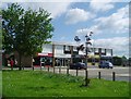
Robin Way Shops
Shops on Tile Kiln Estate
Image: © Paul Franks
Taken: 10 May 2012
0.13 miles
2
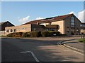
Tile Kiln Church
This independent evangelical church stands in Robin Way and opened in 1972.
Image: © Robert Edwards
Taken: 19 Feb 2010
0.13 miles
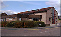
4
Tile Kiln Estate
A 1960's housing estate built on the former Tile Kiln Farm, on the south side of Chelmsford.
Image: © Paul Franks
Taken: 10 May 2012
0.19 miles
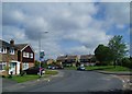
5
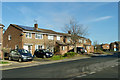
Houses on Linnet Drive
The roads on this estate are named after birds.
Image: © Robin Webster
Taken: 8 Dec 2012
0.23 miles