IMAGES TAKEN NEAR TO
Copland Close, CHELMSFORD, CM2 7NY
Introduction
This page details the photographs taken nearby to Copland Close, CM2 7NY by members of the Geograph project.
The Geograph project started in 2005 with the aim of publishing, organising and preserving representative images for every square kilometre of Great Britain, Ireland and the Isle of Man.

There are currently over 7.5m images from over14,400 individuals and you can help contribute to the project by visiting https://www.geograph.org.uk
Image Map (Loading...)


Getting Data...Please wait
Leaflet Map data © OpenStreetMap
Images are licensed for reuse under creativecommons.org/licenses/by-sa/2.0
Notes
- Clicking on the map will re-center to the selected point.
- The higher the marker number, the further away the image location is from the centre of the postcode.
Image Listing (2 Images Found)
Images are licensed for reuse under creativecommons.org/licenses/by-sa/2.0
Image
Details
Distance
1
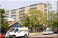
The Vineyards Great Baddow
1960's town planning gone mad, this huge block of flats is part of a development in the centre of a village!!
Image: © Andrew Pickess
Taken: 3 Sep 2005
0.19 miles
2

Great Baddow
Most of the grid can be seen in this photo. Noakes Park and the A1114 Essex Yeomanry Way stand out.
Image: © terry joyce
Taken: 18 Aug 2010
0.23 miles