IMAGES TAKEN NEAR TO
Mascalls Way, CHELMSFORD, CM2 7NR
Introduction
This page details the photographs taken nearby to Mascalls Way, CM2 7NR by members of the Geograph project.
The Geograph project started in 2005 with the aim of publishing, organising and preserving representative images for every square kilometre of Great Britain, Ireland and the Isle of Man.

There are currently over 7.5m images from over14,400 individuals and you can help contribute to the project by visiting https://www.geograph.org.uk
Image Map (Loading...)


Getting Data...Please wait
Leaflet Map data © OpenStreetMap
Images are licensed for reuse under creativecommons.org/licenses/by-sa/2.0
Notes
- Clicking on the map will re-center to the selected point.
- The higher the marker number, the further away the image location is from the centre of the postcode.
Image Listing (7 Images Found)
Images are licensed for reuse under creativecommons.org/licenses/by-sa/2.0
Image
Details
Distance
1
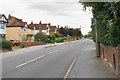
Baddow Road
Part of an established residential area surrounding Chelmsford. The telegraph pole really does lean out.
Image: © Bill Boaden
Taken: 2 Sep 2019
0.21 miles
2
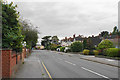
Baddow Road
Part of a more established residential area surrounding Chelmsford, looking in the direction of the city centre.
Image: © Bill Boaden
Taken: 2 Sep 2019
0.21 miles
3
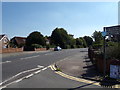
B1009 Baddow Road, Great Baddow
At the entrance of Great Baddow Recreation Ground
Image: © Geographer
Taken: 2 Sep 2018
0.22 miles
4
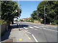
B1009 Baddow Road, Great Baddow
At the entrance of Great Baddow Recreation Ground
Image: © Geographer
Taken: 2 Sep 2018
0.22 miles
5
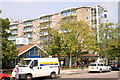
The Vineyards Great Baddow
1960's town planning gone mad, this huge block of flats is part of a development in the centre of a village!!
Image: © Andrew Pickess
Taken: 3 Sep 2005
0.22 miles
6
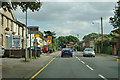
Baddow Road approaches the Beehive Lane corner
This was formerly the main road from Chelmsford to Southend.
Image: © Robin Webster
Taken: 15 Sep 2011
0.24 miles
7
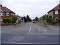
Longfield Road, Great Baddow
At the junction with the B1009 Baddow Road
Image: © Geographer
Taken: 13 Sep 2009
0.25 miles