IMAGES TAKEN NEAR TO
Brewery Fields, Church Street, CHELMSFORD, CM2 7LE
Introduction
This page details the photographs taken nearby to Brewery Fields, Church Street, CM2 7LE by members of the Geograph project.
The Geograph project started in 2005 with the aim of publishing, organising and preserving representative images for every square kilometre of Great Britain, Ireland and the Isle of Man.

There are currently over 7.5m images from over14,400 individuals and you can help contribute to the project by visiting https://www.geograph.org.uk
Image Map (Loading...)


Getting Data...Please wait
Leaflet Map data © OpenStreetMap
Images are licensed for reuse under creativecommons.org/licenses/by-sa/2.0
Notes
- Clicking on the map will re-center to the selected point.
- The higher the marker number, the further away the image location is from the centre of the postcode.
Image Listing (8 Images Found)
Images are licensed for reuse under creativecommons.org/licenses/by-sa/2.0
Image
Details
Distance
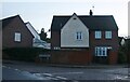
1
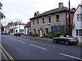
La Vista Italian Restaurant
On Church Street
Image: © Geographer
Taken: 13 Sep 2009
0.19 miles
2
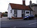
La Vista Italian Restaurant
On Church Street
Image: © Geographer
Taken: 13 Sep 2009
0.19 miles
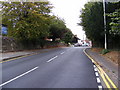
3
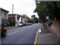
Church Street, Great Baddow
Looking towards the A1114 Southend Road
Road No.C25554
Image: © Geographer
Taken: 13 Sep 2009
0.19 miles
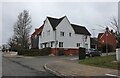
4
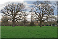
Trees in meadow near Pontlands Park Hotel, Great Baddow
Image: © Roger Jones
Taken: 28 Feb 2016
0.19 miles
6
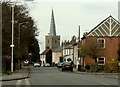
Church Street in Great Baddow
St. Mary's church, in the distance, actually stands in the next grid square.
Image: © Robert Edwards
Taken: 26 Mar 2008
0.21 miles
7
Eastwood Park from West Hanningfield Road
Image: © David Howard
Taken: 12 Mar 2023
0.24 miles
8
Church Street, Great Baddow
Near St.Mary's Church
Road No.C25554
Image: © Geographer
Taken: 13 Sep 2009
0.25 miles