IMAGES TAKEN NEAR TO
The Bringey, CHELMSFORD, CM2 7FQ
Introduction
This page details the photographs taken nearby to The Bringey, CM2 7FQ by members of the Geograph project.
The Geograph project started in 2005 with the aim of publishing, organising and preserving representative images for every square kilometre of Great Britain, Ireland and the Isle of Man.

There are currently over 7.5m images from over14,400 individuals and you can help contribute to the project by visiting https://www.geograph.org.uk
Image Map
Images are licensed for reuse under creativecommons.org/licenses/by-sa/2.0
Notes
- Clicking on the map will re-center to the selected point.
- The higher the marker number, the further away the image location is from the centre of the postcode.
Image Listing (5 Images Found)
Images are licensed for reuse under creativecommons.org/licenses/by-sa/2.0
Image
Details
Distance
3
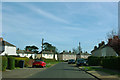
Crescent Road, Great Baddow
The far houses on the left are on Jeffery Road.
Image: © Robin Webster
Taken: 25 Mar 2012
0.24 miles
4
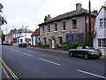
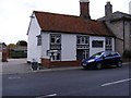
La Vista Italian Restaurant
On Church Street
Image: © Geographer
Taken: 13 Sep 2009
0.25 miles
5
La Vista Italian Restaurant
On Church Street
Image: © Geographer
Taken: 13 Sep 2009
0.25 miles