IMAGES TAKEN NEAR TO
Jeffcut Road, CHELMSFORD, CM2 6XN
Introduction
This page details the photographs taken nearby to Jeffcut Road, CM2 6XN by members of the Geograph project.
The Geograph project started in 2005 with the aim of publishing, organising and preserving representative images for every square kilometre of Great Britain, Ireland and the Isle of Man.

There are currently over 7.5m images from over14,400 individuals and you can help contribute to the project by visiting https://www.geograph.org.uk
Image Map
Images are licensed for reuse under creativecommons.org/licenses/by-sa/2.0
Notes
- Clicking on the map will re-center to the selected point.
- The higher the marker number, the further away the image location is from the centre of the postcode.
Image Listing (8 Images Found)
Images are licensed for reuse under creativecommons.org/licenses/by-sa/2.0
Image
Details
Distance
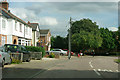
1
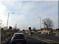
A138 Chelmer Road, Chelmsford
At the junction with Sandford Road
Image: © Geographer
Taken: 15 Feb 2015
0.06 miles
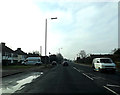
2
A138 Chelmer Road, Chelmsford
At the junction with Sandford Road
Image: © Geographer
Taken: 15 Feb 2015
0.06 miles
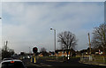
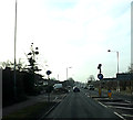
3
Sandford Road, Chelmsford
At the junction with the A138 Chelmer Road
Image: © Geographer
Taken: 15 Feb 2015
0.08 miles
4
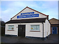
Springfield Park Baptist Church Chelmsford Essex
Situated in Springfield Park Road, Springfield, Chelmsford.
Image: © Peter Stack
Taken: 26 Jan 2008
0.11 miles
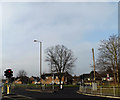
5
Houses on Sandford Road
Is the crime rate any better in this area, with the Essex Police headquarters close by?
Image: © Robin Webster
Taken: 15 Sep 2011
0.17 miles
8
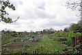
Allotments Near Coronation Park
Looking over the fence from the public recreation ground.
Image: © Glyn Baker
Taken: 13 Apr 2017
0.24 miles