IMAGES TAKEN NEAR TO
Pollards Green, CHELMSFORD, CM2 6UH
Introduction
This page details the photographs taken nearby to Pollards Green, CM2 6UH by members of the Geograph project.
The Geograph project started in 2005 with the aim of publishing, organising and preserving representative images for every square kilometre of Great Britain, Ireland and the Isle of Man.

There are currently over 7.5m images from over14,400 individuals and you can help contribute to the project by visiting https://www.geograph.org.uk
Image Map
Images are licensed for reuse under creativecommons.org/licenses/by-sa/2.0
Notes
- Clicking on the map will re-center to the selected point.
- The higher the marker number, the further away the image location is from the centre of the postcode.
Image Listing (5 Images Found)
Images are licensed for reuse under creativecommons.org/licenses/by-sa/2.0
Image
Details
Distance
1
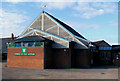
Church of Our Saviour, Chelmer Village, Chelmsford, Essex
Image: © Peter Stack
Taken: 22 Aug 2009
0.15 miles
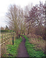
3
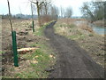
Chelmer and Blackwater Navigation
Maintenance work is under way on the towpath. Large trees have been cut down, and much replanting of young trees is taking place. The towpath is being resurfaced.
Image: © Robin Lucas
Taken: 13 Feb 2015
0.21 miles
4
Saffron Trail Footpath near River Chelmer, Springfield, Chelmsford
Image: © Roger Jones
Taken: 28 Dec 2018
0.22 miles