IMAGES TAKEN NEAR TO
Barlows Reach, CHELMSFORD, CM2 6SN
Introduction
This page details the photographs taken nearby to Barlows Reach, CM2 6SN by members of the Geograph project.
The Geograph project started in 2005 with the aim of publishing, organising and preserving representative images for every square kilometre of Great Britain, Ireland and the Isle of Man.

There are currently over 7.5m images from over14,400 individuals and you can help contribute to the project by visiting https://www.geograph.org.uk
Image Map (Loading...)


Getting Data...Please wait
Leaflet Map data © OpenStreetMap
Images are licensed for reuse under creativecommons.org/licenses/by-sa/2.0
Notes
- Clicking on the map will re-center to the selected point.
- The higher the marker number, the further away the image location is from the centre of the postcode.
Image Listing (6 Images Found)
Images are licensed for reuse under creativecommons.org/licenses/by-sa/2.0
Image
Details
Distance
1

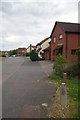
Suburban Footpath
The right of way status of this path is uncertain however there are bollards at each end to prevent motor traffic.
Image: © Glyn Baker
Taken: 13 Apr 2017
0.04 miles
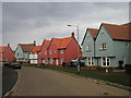
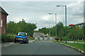
2
Barlow's Reach
Modern houses in Chelmsford
Image: © Glyn Baker
Taken: 13 Apr 2017
0.09 miles
3
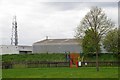
The Pillbox Play Area
The pillbox appears to be long gone, however the stop line is commemorated by the name of this playground for the eights and under.
Image: © Glyn Baker
Taken: 13 Apr 2017
0.11 miles
4
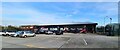
Jump Street, Chelmsford
Jump, Climb, Play, Chelmsford, all sorts of active pursuits indoors, biggest in Essex, see; https://jumpstreet.co.uk/chelmsford-activity-centre/
Image: © Chris Morgan
Taken: 27 Dec 2022
0.12 miles
5
Houses in Abell Way, Chancellor Park, Chelmsford
These homes were built by Bryant Homes.
Image: © John Brightley
Taken: 13 May 2004
0.22 miles
6
That's not the way out!
The Chelmer Village development is a maze of small streets, and having got into it, it is a slight worry getting out again. This blocked connection between the residential and commercial areas is clearly not the way to go!
Image: © Robin Webster
Taken: 15 Sep 2011
0.23 miles