IMAGES TAKEN NEAR TO
Storms Way, CHELMSFORD, CM2 6NU
Introduction
This page details the photographs taken nearby to Storms Way, CM2 6NU by members of the Geograph project.
The Geograph project started in 2005 with the aim of publishing, organising and preserving representative images for every square kilometre of Great Britain, Ireland and the Isle of Man.

There are currently over 7.5m images from over14,400 individuals and you can help contribute to the project by visiting https://www.geograph.org.uk
Image Map (Loading...)


Getting Data...Please wait
Leaflet Map data © OpenStreetMap
Images are licensed for reuse under creativecommons.org/licenses/by-sa/2.0
Notes
- Clicking on the map will re-center to the selected point.
- The higher the marker number, the further away the image location is from the centre of the postcode.
Image Listing (3 Images Found)
Images are licensed for reuse under creativecommons.org/licenses/by-sa/2.0
Image
Details
Distance
1
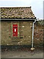
Victorian post box
Embedded in the wall of an old farm building
Image: © Paul Jones
Taken: 22 Feb 2022
0.07 miles
2
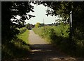
Public footpath to Chelmer Village from Sandford Mill Road
Image: © Robert Edwards
Taken: 8 Jun 2008
0.10 miles
3
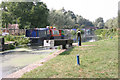
Sandford Lock
Sandford Lock on the 'Chelmer and Blackwater Navigation Canal. Completed in 1797 its 14 mile length from Chelmsford to Heybridge bypassed the River Chelmer and The Blackwater. It drops 77' through 12 locks.
Image: © Andrew Pickess
Taken: 3 Sep 2005
0.18 miles