IMAGES TAKEN NEAR TO
Chelmer Road, CHELMSFORD, CM2 6NH
Introduction
This page details the photographs taken nearby to Chelmer Road, CM2 6NH by members of the Geograph project.
The Geograph project started in 2005 with the aim of publishing, organising and preserving representative images for every square kilometre of Great Britain, Ireland and the Isle of Man.

There are currently over 7.5m images from over14,400 individuals and you can help contribute to the project by visiting https://www.geograph.org.uk
Image Map
Images are licensed for reuse under creativecommons.org/licenses/by-sa/2.0
Notes
- Clicking on the map will re-center to the selected point.
- The higher the marker number, the further away the image location is from the centre of the postcode.
Image Listing (10 Images Found)
Images are licensed for reuse under creativecommons.org/licenses/by-sa/2.0
Image
Details
Distance
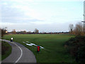
1
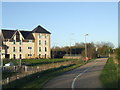
Shared path, Chelmsford
This path in Chelmsford is shared by cyclists and pedestrians.
Image: © Malc McDonald
Taken: 20 Apr 2013
0.12 miles
3
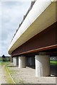
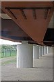
New Bridge on the Old A12
This new bridge over the Chelmer replaced a non-elevated concrete structure from the 1930's. The 1930's A12 Chelmsford bypass has been bypassed for about 30 years so the road above is designated the A138. You can take a look Image
Image: © Glyn Baker
Taken: 13 Apr 2017
0.16 miles
4
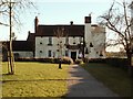
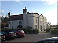
'Fox & Raven' inn near Chelmer Village
Image: © Robert Edwards
Taken: 5 Mar 2006
0.16 miles
5
The Fox and Raven, Chelmer Village
A popular pub/restaurant close by the River Chelmer.
Image: © Trevor Harris
Taken: 22 Nov 2013
0.20 miles
6
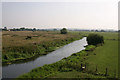
River Chelmer
The River Chelmer as it leaves Chelmsford, after heavy rain there is nearly always flooding here.
Image: © Andrew Pickess
Taken: 3 Sep 2005
0.22 miles
7
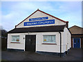
Springfield Park Baptist Church Chelmsford Essex
Situated in Springfield Park Road, Springfield, Chelmsford.
Image: © Peter Stack
Taken: 26 Jan 2008
0.23 miles
8
Watered Fields
This is one of a number of fields next to the Chelmer & Blackwater Navigation at Springfield, Chelmsford that gets flooded when there is a high flow from the River Can and River Chelmer.
Image: © terry joyce
Taken: 21 Jan 2011
0.24 miles
9
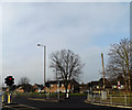
Sandford Road, Chelmsford
At the junction with the A138 Chelmer Road
Image: © Geographer
Taken: 15 Feb 2015
0.24 miles
10
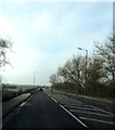
A138 Chelmer Road, Chelmsford
At the River Chelmer Bridge
Image: © Geographer
Taken: 15 Feb 2015
0.25 miles