IMAGES TAKEN NEAR TO
Springfield Road, CHELMSFORD, CM2 6JA
Introduction
This page details the photographs taken nearby to Springfield Road, CM2 6JA by members of the Geograph project.
The Geograph project started in 2005 with the aim of publishing, organising and preserving representative images for every square kilometre of Great Britain, Ireland and the Isle of Man.

There are currently over 7.5m images from over14,400 individuals and you can help contribute to the project by visiting https://www.geograph.org.uk
Image Map (Loading...)


Getting Data...Please wait
Leaflet Map data © OpenStreetMap
Images are licensed for reuse under creativecommons.org/licenses/by-sa/2.0
Notes
- Clicking on the map will re-center to the selected point.
- The higher the marker number, the further away the image location is from the centre of the postcode.
Image Listing (29 Images Found)
Images are licensed for reuse under creativecommons.org/licenses/by-sa/2.0
Image
Details
Distance
1
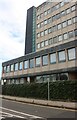
Office block on Victoria Road, Chelmsford
It's called Rivers House and the way in is round the corner on the right. This is the side of the building.
Image: © David Howard
Taken: 25 Aug 2024
0.07 miles
3
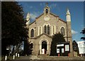
Holy Trinity church, Springfield, Essex
This church is in Trinity Road and it was built in 1843 in the Neo-Norman style. It was designed by F.Adie Repton.
Image: © Robert Edwards
Taken: 5 Mar 2006
0.09 miles
4
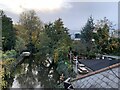
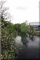
River Chelmer from the Riverside Inn, Chelmsford
Image: © Jonathan Hutchins
Taken: 10 Nov 2018
0.12 miles
5
Apple Blossom by the Chelmer
Taken from the Victoria Rd bridge looking towards the leisure centre
Image: © Glyn Baker
Taken: 13 Apr 2017
0.14 miles
7
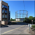
Chelmsford: Wharf Road and gasholder
The gasholder site has been acquired by the City Council for housing. The Grade II listed gasholder frames are to be incorporated in whatever is built, acknowledging the area's industrial past.
Image: © John Sutton
Taken: 22 Jun 2018
0.15 miles
8
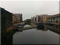
Chelmer and Blackwater Navigation: summit basin
Image: © Christopher Hilton
Taken: 15 Oct 2018
0.15 miles
9
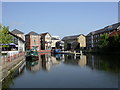
Chelmsford, canal basin
Springfield Basin, inland terminus of the Chelmer & Blackwater Navigation. http://www.chelmercanaltrust.co.uk/cbmap.htm
Image: © Mike Faherty
Taken: 15 May 2010
0.16 miles
10
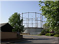
Chelmsford, gasometer
One of two at the gasworks in Wharf Road.
Image: © Mike Faherty
Taken: 15 May 2010
0.16 miles