IMAGES TAKEN NEAR TO
Springfield Road, CHELMSFORD, CM2 6BJ
Introduction
This page details the photographs taken nearby to Springfield Road, CM2 6BJ by members of the Geograph project.
The Geograph project started in 2005 with the aim of publishing, organising and preserving representative images for every square kilometre of Great Britain, Ireland and the Isle of Man.

There are currently over 7.5m images from over14,400 individuals and you can help contribute to the project by visiting https://www.geograph.org.uk
Image Map
Images are licensed for reuse under creativecommons.org/licenses/by-sa/2.0
Notes
- Clicking on the map will re-center to the selected point.
- The higher the marker number, the further away the image location is from the centre of the postcode.
Image Listing (9 Images Found)
Images are licensed for reuse under creativecommons.org/licenses/by-sa/2.0
Image
Details
Distance
1
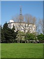
Essex Police HQ, Springfield, Chelmsford
Vaguely Orwellian structure.
Image: © John Myers
Taken: 6 May 2008
0.03 miles
2
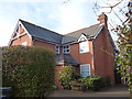
New house, Springfield Road, Chelmsford
Image: © Alex McGregor
Taken: 18 Jan 2012
0.13 miles
3
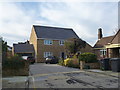
New house, Dalrymple Close, Chelmsford
Image: © Alex McGregor
Taken: 18 Jan 2012
0.20 miles
4
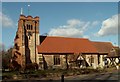
All Saints church, Springfield, Essex
This church dates back to the Norman period. The chancel and tower were built in the 14th century and the brick built section of the tower was a rebuild done in 1586.
Image: © Robert Edwards
Taken: 5 Mar 2006
0.23 miles
5
Old Boundary Marker on Sanford Road, Chelmsford
Prison Commission Boundary Marker set in the midpoint of the front garden wall between Nos. 24 and 26 on the south side of Sandford Road, Chelmsford. Marking the northeast boundary of Chelmsford Prison.
Milestone Society National ID: EX_PCCHEL18em
Image: © M Bardell
Taken: 16 Mar 2022
0.24 miles
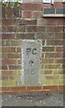
6

Old Boundary Marker on Sanford Road, Chelmsford
Prison Commission Boundary Marker set in the front garden wall of No. 26 on the south side of Sandford Road, Chelmsford. Marking the northeast boundary of Chelmsford Prison.
Milestone Society National ID: EX_PCCHEL17em
Image: © M Bardell
Taken: 16 Mar 2022
0.24 miles
8

Old Boundary Marker on Sanford Road, Chelmsford
Prison Commission Boundary Marker set in the front garden wall of No. 32 on the south side of Sandford Road, Chelmsford. Marking the northeast boundary of Chelmsford Prison.
Milestone Society National ID: EX_PCCHEL15Bem
Image: © M Bardell
Taken: 16 Mar 2022
0.25 miles
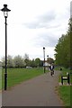
9
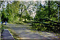
Storm damage, 1987
After the great storm of the previous night, fallen trees have been partly cleared in Stump Lane, Springfield.
Image: © Robin Webster
Taken: 16 Oct 1987
0.25 miles