IMAGES TAKEN NEAR TO
Drovers Way, CHELMSFORD, CM2 5PS
Introduction
This page details the photographs taken nearby to Drovers Way, CM2 5PS by members of the Geograph project.
The Geograph project started in 2005 with the aim of publishing, organising and preserving representative images for every square kilometre of Great Britain, Ireland and the Isle of Man.

There are currently over 7.5m images from over14,400 individuals and you can help contribute to the project by visiting https://www.geograph.org.uk
Image Map
Images are licensed for reuse under creativecommons.org/licenses/by-sa/2.0
Notes
- Clicking on the map will re-center to the selected point.
- The higher the marker number, the further away the image location is from the centre of the postcode.
Image Listing (29 Images Found)
Images are licensed for reuse under creativecommons.org/licenses/by-sa/2.0
Image
Details
Distance
3
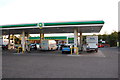
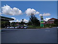
Petrol station and M&S outlet
In the services area at Boreham Interchange on the A12.
Image: © Trevor Harris
Taken: 12 Sep 2011
0.04 miles
4
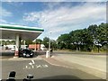
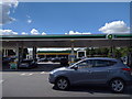
Boreham services, north of Chelmsford
On the left, the filling station for cars: on the right, the large concrete apron leading to the HGV pumps just off the right of the photo.
Image: © Christopher Hilton
Taken: 2 Jun 2019
0.05 miles
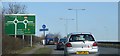
8
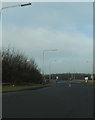
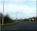
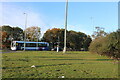
Roundabout on the A12 exit heading for the A130
Image: © David Howard
Taken: 15 May 2012
0.10 miles