IMAGES TAKEN NEAR TO
STANSTED, CM24 8TL
Introduction
This page details the photographs taken nearby to CM24 8TL by members of the Geograph project.
The Geograph project started in 2005 with the aim of publishing, organising and preserving representative images for every square kilometre of Great Britain, Ireland and the Isle of Man.

There are currently over 7.5m images from over14,400 individuals and you can help contribute to the project by visiting https://www.geograph.org.uk
Image Map
Images are licensed for reuse under creativecommons.org/licenses/by-sa/2.0
Notes
- Clicking on the map will re-center to the selected point.
- The higher the marker number, the further away the image location is from the centre of the postcode.
Image Listing (6 Images Found)
Images are licensed for reuse under creativecommons.org/licenses/by-sa/2.0
Image
Details
Distance
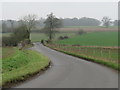
2
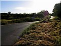
Bentfield Bury Farms near Stansted Mountfitchet
A private access road leading into Bentfield Bury Farms in the north Essex countryside, near the village of Stansted Mountfitchet.
Image: © Malc McDonald
Taken: 25 Jan 2020
0.08 miles
3
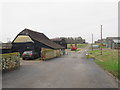
Farm access road near Stansted Mountfitchet
An access road into Bentfield Bury Farms, in the north Essex countryside near the village of Stansted Mountfitchet.
Image: © Malc McDonald
Taken: 25 Jan 2020
0.09 miles
5
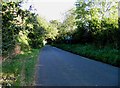
Minor road near Manuden
A minor road in the Essex countryside, near the village of Manuden.
This road is on the route of National Cycle Network route 11.
Image: © Malc McDonald
Taken: 25 Jan 2020
0.23 miles
6
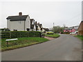
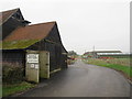
Bentfield Bower, near Stansted Mountfitchet
Bentfield Bower is a small hamlet in the north Essex countryside, near the village of Stansted Mountfitchet.
The road passing through is on the route of National Cycle Network route 11.
Image: © Malc McDonald
Taken: 25 Jan 2020
0.23 miles