IMAGES TAKEN NEAR TO
Stoney Place, STANSTED, CM24 8PE
Introduction
This page details the photographs taken nearby to Stoney Place, CM24 8PE by members of the Geograph project.
The Geograph project started in 2005 with the aim of publishing, organising and preserving representative images for every square kilometre of Great Britain, Ireland and the Isle of Man.

There are currently over 7.5m images from over14,400 individuals and you can help contribute to the project by visiting https://www.geograph.org.uk
Image Map
Images are licensed for reuse under creativecommons.org/licenses/by-sa/2.0
Notes
- Clicking on the map will re-center to the selected point.
- The higher the marker number, the further away the image location is from the centre of the postcode.
Image Listing (59 Images Found)
Images are licensed for reuse under creativecommons.org/licenses/by-sa/2.0
Image
Details
Distance
1
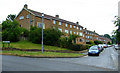
Manor Road
At Mount Drive, which is to the left.
Image: © Thomas Nugent
Taken: 12 Jun 2011
0.03 miles
2
Stoney Common
Looking up the hill from West Road.
Image: © Thomas Nugent
Taken: 12 Jun 2011
0.11 miles
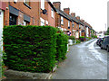
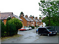
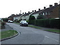
3
Priory Drive
Off Maitland Road, looking towards Mountfitchet Road.
Image: © Thomas Nugent
Taken: 28 Jul 2008
0.12 miles
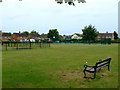
5
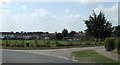
Recreation ground
At the corner of Mount Drive and Maitland Road.
Image: © Thomas Nugent
Taken: 28 Jul 2008
0.12 miles
6
Stoney Common
Viewed from Stoney Common Road.
Image: © Thomas Nugent
Taken: 12 Jun 2011
0.15 miles
7
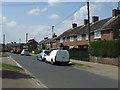
Maitland Road
At the junction with Priory Drive.
Image: © Thomas Nugent
Taken: 28 Jul 2008
0.15 miles
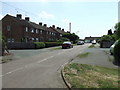
8
West Road
Stoney Common is on the right.
Image: © Thomas Nugent
Taken: 12 Jun 2011
0.15 miles
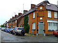
10
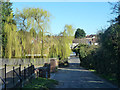
Stony Common Road, Stansted Mountfitchet
Image: © Robin Webster
Taken: 16 Mar 2014
0.15 miles