IMAGES TAKEN NEAR TO
Stoneyfield Drive, STANSTED, CM24 8PA
Introduction
This page details the photographs taken nearby to Stoneyfield Drive, CM24 8PA by members of the Geograph project.
The Geograph project started in 2005 with the aim of publishing, organising and preserving representative images for every square kilometre of Great Britain, Ireland and the Isle of Man.

There are currently over 7.5m images from over14,400 individuals and you can help contribute to the project by visiting https://www.geograph.org.uk
Image Map
Images are licensed for reuse under creativecommons.org/licenses/by-sa/2.0
Notes
- Clicking on the map will re-center to the selected point.
- The higher the marker number, the further away the image location is from the centre of the postcode.
Image Listing (156 Images Found)
Images are licensed for reuse under creativecommons.org/licenses/by-sa/2.0
Image
Details
Distance
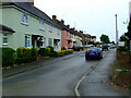
1
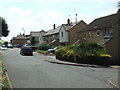
The Spinney
A residential street to the south of the railway line.
Image: © Thomas Nugent
Taken: 28 Jul 2008
0.02 miles
2
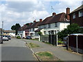
Stoneyfield Drive
A residential street to the south of the railway line.
Image: © Thomas Nugent
Taken: 28 Jul 2008
0.02 miles
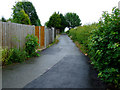
3
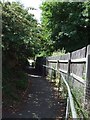
Public footpath
Image: © Thomas Nugent
Taken: 28 Jul 2008
0.03 miles
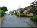
4
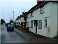
Stoneyfield Drive
Looking away from The Spinney.
Image: © Thomas Nugent
Taken: 12 Jun 2011
0.03 miles
5
Stoneyfield Drive
Looking away from The Spinney.
Image: © Thomas Nugent
Taken: 12 Jun 2011
0.03 miles
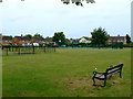
8
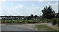
Recreation ground
At the corner of Mount Drive and Maitland Road.
Image: © Thomas Nugent
Taken: 28 Jul 2008
0.05 miles
10
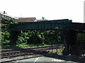
Railway footbridge
Crosses the railway at Water Lane.
Image: © Thomas Nugent
Taken: 28 Jul 2008
0.05 miles