IMAGES TAKEN NEAR TO
Blythwood Gardens, STANSTED, CM24 8HG
Introduction
This page details the photographs taken nearby to Blythwood Gardens, CM24 8HG by members of the Geograph project.
The Geograph project started in 2005 with the aim of publishing, organising and preserving representative images for every square kilometre of Great Britain, Ireland and the Isle of Man.

There are currently over 7.5m images from over14,400 individuals and you can help contribute to the project by visiting https://www.geograph.org.uk
Image Map (Loading...)


Getting Data...Please wait
Leaflet Map data © OpenStreetMap
Images are licensed for reuse under creativecommons.org/licenses/by-sa/2.0
Notes
- Clicking on the map will re-center to the selected point.
- The higher the marker number, the further away the image location is from the centre of the postcode.
Image Listing (95 Images Found)
Images are licensed for reuse under creativecommons.org/licenses/by-sa/2.0
Image
Details
Distance
3
Small garden
On Silver Street at the Blythwood Gardens junction.
Image: © Thomas Nugent
Taken: 28 Jul 2008
0.07 miles
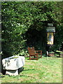
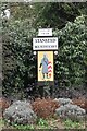
4

Town boundary sign
On Silver Street at Blythwood Gardens.
Image: © Thomas Nugent
Taken: 28 Jul 2008
0.07 miles

7
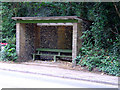
Bus shelter on Silver Street
An interesting use of brick and stone.
Image: © Thomas Nugent
Taken: 12 Jun 2011
0.09 miles
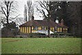
8
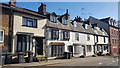
Main Road through Stansted Mountfitchet
Image: © Christine Matthews
Taken: 15 Feb 2018
0.09 miles
10
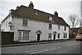
Weatherboarding, Silver St
Grade II listed.
Image: © N Chadwick
Taken: 4 Mar 2023
0.09 miles