IMAGES TAKEN NEAR TO
London Stansted Airport, STANSTED, CM24 1QL
Introduction
This page details the photographs taken nearby to CM24 1QL by members of the Geograph project.
The Geograph project started in 2005 with the aim of publishing, organising and preserving representative images for every square kilometre of Great Britain, Ireland and the Isle of Man.

There are currently over 7.5m images from over14,400 individuals and you can help contribute to the project by visiting https://www.geograph.org.uk
Image Map
Images are licensed for reuse under creativecommons.org/licenses/by-sa/2.0
Notes
- Clicking on the map will re-center to the selected point.
- The higher the marker number, the further away the image location is from the centre of the postcode.
Image Listing (9 Images Found)
Images are licensed for reuse under creativecommons.org/licenses/by-sa/2.0
Image
Details
Distance
1
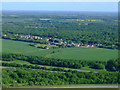
Takeley Street from the air
Seconds after take-off from Stansted.
Image: © Thomas Nugent
Taken: 9 May 2011
0.12 miles
2
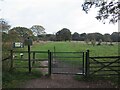
Path into Hatfield Forest, near Bishop's Stortford
A path leading through a gate into Hatfield Forest in north Essex.
This image was taken in the early evening on an October day. Dusk was approaching and it would not be long before darkness fell.
Image: © Malc McDonald
Taken: 29 Oct 2022
0.12 miles
3
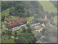
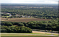
Thremhall Park and Priory
As seen just after take off from Stansted. On Dunmow Road [B1256], just 0.5 km from the end of Runway 23.
Image: © M J Richardson
Taken: 27 Jun 2011
0.15 miles
4
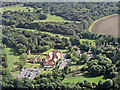
Thremhall Park from the air
Serviced offices and conference facilities near Stansted Airport http://www.thremhallpark.co.uk/ .
Image: © Thomas Nugent
Taken: 14 Sep 2015
0.18 miles
5
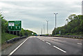
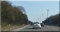
A120 near Stansted Airport
Eastbound, the turn for Stansted is ahead.
Image: © Julian P Guffogg
Taken: 8 May 2015
0.21 miles
6
Takeley Street from the air
The A120 road is in the foreground. The trees are at Hatfield Forest Country Park.
Image: © Thomas Nugent
Taken: 14 Sep 2015
0.23 miles
7
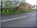
Dunmow Road, Takeley Street
Stansted Airport is behind the fields on the left.
Image: © David Howard
Taken: 25 Apr 2012
0.24 miles
9
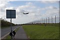
Geographer?s Steed and Route 11
This is National Cycle Route 11 as it passes beside the perimeter fence of Image the venerable old cycle is a 1973 Carlton Corsa.
Image: © Glyn Baker
Taken: 29 Oct 2006
0.25 miles