IMAGES TAKEN NEAR TO
High View, BISHOP'S STORTFORD, CM23 5QG
Introduction
This page details the photographs taken nearby to High View, CM23 5QG by members of the Geograph project.
The Geograph project started in 2005 with the aim of publishing, organising and preserving representative images for every square kilometre of Great Britain, Ireland and the Isle of Man.

There are currently over 7.5m images from over14,400 individuals and you can help contribute to the project by visiting https://www.geograph.org.uk
Image Map
Images are licensed for reuse under creativecommons.org/licenses/by-sa/2.0
Notes
- Clicking on the map will re-center to the selected point.
- The higher the marker number, the further away the image location is from the centre of the postcode.
Image Listing (10 Images Found)
Images are licensed for reuse under creativecommons.org/licenses/by-sa/2.0
Image
Details
Distance
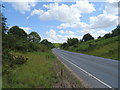
1
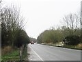
A Birchanger Path
Looking back towards the main Village from the North of Birchanger. This footpath runs parallel to a stream on the right behind the hedge.
Image: © Glyn Baker
Taken: 5 Jul 2013
0.10 miles
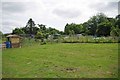
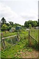
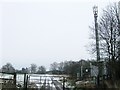
2
Footbridge Near Birchanger Allotments
A plank bridge near Image
Image: © Glyn Baker
Taken: 5 Jul 2013
0.15 miles
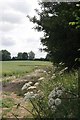
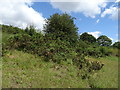
3
Birchanger Allotments
Allotment Gardens on Birchanger Lane
Image: © Glyn Baker
Taken: 5 Jul 2013
0.17 miles
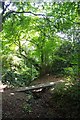
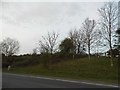
4
Permissive Path to Birchanger lane
This footpath crosses Image
Image: © Glyn Baker
Taken: 5 Jul 2013
0.19 miles
9
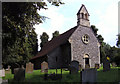
St Mary the Virgin Church, Birchanger, Essex
Image: © Peter Stack
Taken: 9 Aug 2009
0.21 miles