IMAGES TAKEN NEAR TO
Stansted Road, BISHOP'S STORTFORD, CM23 5PT
Introduction
This page details the photographs taken nearby to Stansted Road, CM23 5PT by members of the Geograph project.
The Geograph project started in 2005 with the aim of publishing, organising and preserving representative images for every square kilometre of Great Britain, Ireland and the Isle of Man.

There are currently over 7.5m images from over14,400 individuals and you can help contribute to the project by visiting https://www.geograph.org.uk
Image Map (Loading...)


Getting Data...Please wait
Leaflet Map data © OpenStreetMap
Images are licensed for reuse under creativecommons.org/licenses/by-sa/2.0
Notes
- Clicking on the map will re-center to the selected point.
- The higher the marker number, the further away the image location is from the centre of the postcode.
Image Listing (7 Images Found)
Images are licensed for reuse under creativecommons.org/licenses/by-sa/2.0
Image
Details
Distance
1
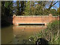
River Stort near Stansted Mountfitchet
Viewed looking upstream, the bridge carries Gipsy Lane over the river.
Image: © Nigel Cox
Taken: 18 Nov 2006
0.08 miles
2
Old Milepost
Old milepost near to Birchanger, Essex on what was the old A.11. For close up view see http://www.geograph.org.uk/photo/1826087
Image: © Keith Evans
Taken: 26 Apr 2010
0.13 miles
3
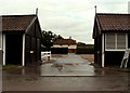
Blyth Farm, near Stansted Mountfitchet, Herts.
This farm stands just over the Essex border in Hertfordshire.
Image: © Robert Edwards
Taken: 18 Aug 2006
0.14 miles
4
Old Milepost
Old milepost near to Birchanger, Essex on what was the old A11. For overall view see http://www.geograph.org.uk/photo/1826085
Image: © Keith Evans
Taken: 26 Apr 2010
0.14 miles
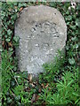
5
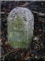
Old Milestone by the B1383, Stansted Road, Birchanger
Carved stone post by the B1383 (was A11), in parish of Birchanger (Uttlesford District), 20m North of bus shelter, by the road, on East side of road. Erected by the Hockerill turnpike trust in the 19th century.
Inscription reads:-
LONDON
30
CAMBRIDGE
24
NEWMARKET
29
Essex HER.
SMR Number: 15780 https://www.heritagegateway.org.uk/Gateway/Results_Single.aspx?uid=MEX1032862&resourceID=1001
Milestone Society National ID: EX_BSGC30
Image: © JV Nicholls
Taken: Unknown
0.14 miles

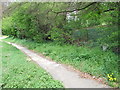
7
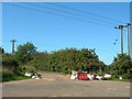
Junction of Tot Lane and Foresthall Road
Major roadworks in the area to the west of Tot Lane should not affect this junction
Image: © John Smith
Taken: 8 Sep 2006
0.18 miles