IMAGES TAKEN NEAR TO
Hazel End, BISHOP'S STORTFORD, CM23 1HG
Introduction
This page details the photographs taken nearby to Hazel End, CM23 1HG by members of the Geograph project.
The Geograph project started in 2005 with the aim of publishing, organising and preserving representative images for every square kilometre of Great Britain, Ireland and the Isle of Man.

There are currently over 7.5m images from over14,400 individuals and you can help contribute to the project by visiting https://www.geograph.org.uk
Image Map
Images are licensed for reuse under creativecommons.org/licenses/by-sa/2.0
Notes
- Clicking on the map will re-center to the selected point.
- The higher the marker number, the further away the image location is from the centre of the postcode.
Image Listing (4 Images Found)
Images are licensed for reuse under creativecommons.org/licenses/by-sa/2.0
Image
Details
Distance
1
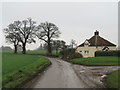
House in the countryside near Stansted Mountfitchet
A house in north Essex countryside near the village of Stansted Mountfitchet.
Image: © Malc McDonald
Taken: 25 Jan 2020
0.03 miles
2
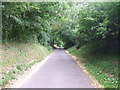
Minor road rising from the ford at Bourne Bridge
Image: © David Beresford
Taken: 15 Aug 2013
0.18 miles
4
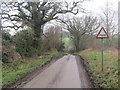
Country lane near Stansted Mountfitchet
A minor lane through north Essex countryside, near the village of Stansted Mountfitchet. The sign to the right of the road warns of a ford ahead.
Image: © Malc McDonald
Taken: 25 Jan 2020
0.24 miles