IMAGES TAKEN NEAR TO
Church Road, BISHOP'S STORTFORD, CM22 7TS
Introduction
This page details the photographs taken nearby to Church Road, CM22 7TS by members of the Geograph project.
The Geograph project started in 2005 with the aim of publishing, organising and preserving representative images for every square kilometre of Great Britain, Ireland and the Isle of Man.

There are currently over 7.5m images from over14,400 individuals and you can help contribute to the project by visiting https://www.geograph.org.uk
Image Map
Images are licensed for reuse under creativecommons.org/licenses/by-sa/2.0
Notes
- Clicking on the map will re-center to the selected point.
- The higher the marker number, the further away the image location is from the centre of the postcode.
Image Listing (6 Images Found)
Images are licensed for reuse under creativecommons.org/licenses/by-sa/2.0
Image
Details
Distance
1
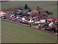
Houses at Bedlar's Green
Seen about 2.5km from landing at Stansted Airport.
Image: © M J Richardson
Taken: 6 Feb 2018
0.07 miles
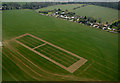
3

Cereal plots at Great Hallingbury
Trial plots - different cereal cultivars have slightly different colours and ripeness, which explains the pattern. See Tam Nugent's image from last year Image and http://www.harlow-ag.co.uk/trials.htm.
Image: © M J Richardson
Taken: 12 Jul 2017
0.14 miles
4
Farmland near Great Hallingbury from the air
On final approach to Stansted from the south west.
I think the square section in the field is wheat seed trails. Click on this http://www.harlow-ag.co.uk/trials.htm for more information.
Image: © Thomas Nugent
Taken: 16 Mar 2016
0.16 miles
5
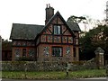
East Lodge, nr.Great Hallingbury, Essex
Image: © Robert Edwards
Taken: 22 Mar 2006
0.24 miles
6
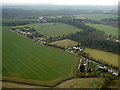
Great Hallingbury from the air
Church Road, with Long Plantation in the background.
Image: © Thomas Nugent
Taken: 16 Mar 2016
0.24 miles