IMAGES TAKEN NEAR TO
The Plashets, BISHOP'S STORTFORD, CM22 7NW
Introduction
This page details the photographs taken nearby to The Plashets, CM22 7NW by members of the Geograph project.
The Geograph project started in 2005 with the aim of publishing, organising and preserving representative images for every square kilometre of Great Britain, Ireland and the Isle of Man.

There are currently over 7.5m images from over14,400 individuals and you can help contribute to the project by visiting https://www.geograph.org.uk
Image Map (Loading...)


Getting Data...Please wait
Leaflet Map data © OpenStreetMap
Images are licensed for reuse under creativecommons.org/licenses/by-sa/2.0
Notes
- Clicking on the map will re-center to the selected point.
- The higher the marker number, the further away the image location is from the centre of the postcode.
Image Listing (7 Images Found)
Images are licensed for reuse under creativecommons.org/licenses/by-sa/2.0
Image
Details
Distance
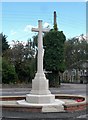
2
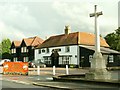
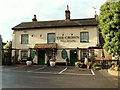
'The Cock' inn and war memorial, Sheering, Essex
Image: © Robert Edwards
Taken: 22 Sep 2006
0.13 miles
4
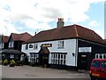
The Cock, Sheering
Built in C17 as a house and converted into a pub at a later date. See http://www.britishlistedbuildings.co.uk/en-118279-the-cock-public-house-sheering-essex#.VewVYRFViko for entry in British Listed Buildings.
Image: © Bikeboy
Taken: 28 Aug 2015
0.13 miles
5
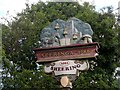
Village sign Sheering
Sceringa is the name of the village recorded in the Domesday Book 1086.
Image: © Bikeboy
Taken: 28 Aug 2015
0.16 miles