IMAGES TAKEN NEAR TO
Mead Way, BISHOP'S STORTFORD, CM22 7FD
Introduction
This page details the photographs taken nearby to Mead Way, CM22 7FD by members of the Geograph project.
The Geograph project started in 2005 with the aim of publishing, organising and preserving representative images for every square kilometre of Great Britain, Ireland and the Isle of Man.

There are currently over 7.5m images from over14,400 individuals and you can help contribute to the project by visiting https://www.geograph.org.uk
Image Map
Images are licensed for reuse under creativecommons.org/licenses/by-sa/2.0
Notes
- Clicking on the map will re-center to the selected point.
- The higher the marker number, the further away the image location is from the centre of the postcode.
Image Listing (10 Images Found)
Images are licensed for reuse under creativecommons.org/licenses/by-sa/2.0
Image
Details
Distance
1
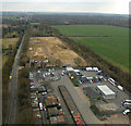
Stansted Distribution Centre from the air
Transport related businesses off the B1256 Dunmow Road.
Image: © Thomas Nugent
Taken: 16 Mar 2016
0.08 miles
2
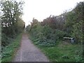
Flitch Way near Bishop's Stortford
A view along the westernmost section of Flitch Way, looking towards Bishop's Stortford. Although this section is open to cyclists as well as walkers, the National Cycle Network turns off to the right, as indicated by the small blue sign on the bench seat.
Image: © Malc McDonald
Taken: 29 Oct 2022
0.08 miles
3
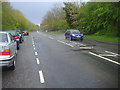
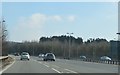
Dunmow Road, Birchanger
Stansted Airport is on the left behind the trees.
Image: © David Howard
Taken: 25 Apr 2012
0.09 miles
5
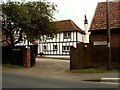
Great Hallingbury End, Takeley, Essex
Image: © Robert Edwards
Taken: 1 Sep 2006
0.13 miles
6
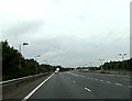
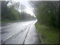
A120 slip road approaching Priory Wood roundabout
Image: © Geographer
Taken: 2 Aug 2014
0.15 miles
7
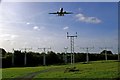
Stansted Approach
These are the runway approach beacons for Stansted Airport on Start Hill near Tilekiln Green.
Image: © Glyn Baker
Taken: 29 Oct 2006
0.17 miles
9
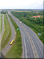
The A120 from the air
The yellow coach is on Long Border Road which runs between the A120 and Stansted Airport's perimeter road.
Image: © Thomas Nugent
Taken: 29 Jul 2011
0.17 miles
10
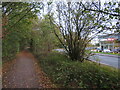
National Cycle Network route 16 near Stansted Airport
This path alongside the B1256 road is a shared path for pedestrians and cyclists. It forms part of National Cycle Network route 16 as it skirts to the south of Stansted Airport.
A car showroom is visible on the opposite side of the road.
Image: © Malc McDonald
Taken: 29 Oct 2022
0.24 miles